IMAGES TAKEN NEAR TO
Cwrt Stan Richards, CARDIFF, CF5 5BF
Introduction
This page details the photographs taken nearby to Cwrt Stan Richards, CF5 5BF by members of the Geograph project.
The Geograph project started in 2005 with the aim of publishing, organising and preserving representative images for every square kilometre of Great Britain, Ireland and the Isle of Man.

There are currently over 7.5m images from over14,400 individuals and you can help contribute to the project by visiting https://www.geograph.org.uk
Image Map
Images are licensed for reuse under creativecommons.org/licenses/by-sa/2.0
Notes
- Clicking on the map will re-center to the selected point.
- The higher the marker number, the further away the image location is from the centre of the postcode.
Image Listing (34 Images Found)
Images are licensed for reuse under creativecommons.org/licenses/by-sa/2.0
Image
Details
Distance
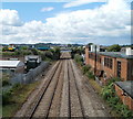
1
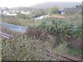
River Ely, west of Cardiff
The River Ely is one of three that flow into the Severn at Cardiff (the others are the Taff and the Rhymney). The railway line in the foreground is the main Cardiff -Swansea line; the concreted area on the left is the remains of the Arjo Wiggins paper mill.
Image: © John Thorn
Taken: 23 Nov 2006
0.08 miles
2
South side of Robert Street, Ely, Cardiff
Viewed from Dyfig Road. http://www.geograph.org.uk/photo/2166967 to the north side of the street
Image: © Jaggery
Taken: 19 Nov 2010
0.14 miles
3
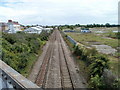
South Wales main line, Ely, Cardiff
Viewed from the bridge adjacent to the roundabout at which Cowbridge Road East meets Cowbridge Road West (and at which Western Avenue enters from the north).
Next station is this direction is Cardiff Central.
The white premises on the left are a Floors-2-Go warehouse.
On the right is an extensive area of wasteland, part of which was formerly occupied by Ely Paper Mill.
Image: © Jaggery
Taken: 22 Jul 2010
0.15 miles
4
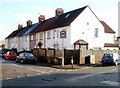
Lloyds TSB Victoria Park, Cardiff
Bank branch at 514 Cowbridge Road East, on the corner of Mayfield Avenue.
Image: © Jaggery
Taken: 22 Jul 2010
0.16 miles
5
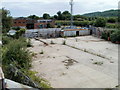
Derelict land adjacent to former Ely Paper Mill, Cardiff
This area of land is in a small triangle created by two sets of railway lines.
It is near the west side of Paper Mill Road. The use of the vanished building which once stood here was probably connected with the mill, which closed in 1999 and has since been demolished. Formerly, access to the mill was via a now blocked-off road http://www.geograph.org.uk/photo/1981977 under a railway bridge.
Image: © Jaggery
Taken: 22 Jul 2010
0.16 miles
6
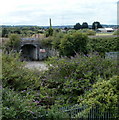
Blocked-off access to former Ely Paper Mill, Cardiff
Viewed from a bridge across the South Wales main railway line, to the south of Cowbridge Road East.
The now blocked-off road under the bridge was formerly part of the route along Paper Mill Road into the now-demolished Ely Paper Mill which closed in 1999. On the far side of the bridge is a large area of wasteland.
Image: © Jaggery
Taken: 22 Jul 2010
0.16 miles
7

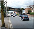
SA Best Bitter Bridge, Cowbridge Road East, Cardiff
The view from the NW shows bridge advertising for a famous product of local brewers Brains.
The other side of the bridge http://www.geograph.org.uk/photo/1982475 advertises a different product, now owned by Brains.
The railway bridge is close to Waun-gron Park station.
Image: © Jaggery
Taken: 22 Jul 2010
0.16 miles
8
Hancocks Beers bridge, Cowbridge Road East, Cardiff
The advertising on the SE side of the bridge is for Hancocks Beer. Formerly a separate company, Hancocks was bought by Bass in 1968. Bass sold Hancocks to Cardiff brewers Brains in 1999. The other side of the bridge advertises Brains SA. http://www.geograph.org.uk/photo/1982486
The railway bridge is close to Waun-gron Park station.
Image: © Jaggery
Taken: 22 Jul 2010
0.16 miles
9
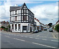
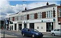
Ty-Pwll Coch pub, Victoria Park, Cardiff
Pub located on the corner of Cowbridge Road East and Windway Road. Probably more than a century old, but looking more recent because of its mock-Tudor appearance, dating from the 1930s.
Image: © Jaggery
Taken: 22 Jul 2010
0.16 miles
10
One railway bridge viewed from another, Victoria Park, Cardiff
The bridge on which the photographer is standing is near the south side of Cowbridge Road East, adjacent to the Mayfield Avenue junction. The bridge in the distance carries the track heading for Waun-gron Park station across the South Wales main line, which is heading away from Cardiff Central towards Pontyclun station, about 15 kilometres distant.
Image: © Jaggery
Taken: 22 Jul 2010
0.16 miles