IMAGES TAKEN NEAR TO
Kingsley Terrace, MERTHYR TYDFIL, CF48 4PH
Introduction
This page details the photographs taken nearby to Kingsley Terrace, CF48 4PH by members of the Geograph project.
The Geograph project started in 2005 with the aim of publishing, organising and preserving representative images for every square kilometre of Great Britain, Ireland and the Isle of Man.

There are currently over 7.5m images from over14,400 individuals and you can help contribute to the project by visiting https://www.geograph.org.uk
Image Map
Images are licensed for reuse under creativecommons.org/licenses/by-sa/2.0
Notes
- Clicking on the map will re-center to the selected point.
- The higher the marker number, the further away the image location is from the centre of the postcode.
Image Listing (70 Images Found)
Images are licensed for reuse under creativecommons.org/licenses/by-sa/2.0
Image
Details
Distance
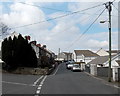
1
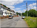
Kingsley terrace, Bryn Taf, Aberfan
Looking north towards the village centre - the view south from the same point is shown at http://www.geograph.org.uk/photo/2485447. The road runs more or less along a contour, as did the former canal and railway which once ran roughly parallel to it (a little down the valley side to the right).
Notice the ridge in the distance. It was on this ridge that the mining spoil-heap was sited which, when it collapsed in October 1966, brought about one of the most horrific disasters in British history. See John Thorn's Image; and also Alan George's first-rate website for coverage of all aspects of the history of the Merthyr area http://www.alangeorge.co.uk/old_merthyr.htm.
Image: © Stefan Czapski
Taken: 20 Jun 2011
0.03 miles
2
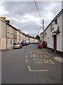
Perthygleision, Aberfan
Looking south along the street which for parts of its length is also known as Noel Terrace and Walter's Terrace. The plan of Aberfan might be thought of as a bit like the constellation known as the Plough - with Perthygleision and Bryn Taf forming a long handle at the southern end of the village.
This view gives absolutely no impression of the steepness of the hillside on which this former mining village stands, as Perthygleision runs pretty much along a contour, along the valley side.
Happily, the name 'Perthygleision' has never had to give way to an English equivalent, though I remember being told - long ago - that it meant something like 'Green Hedges'.
Image: © Stefan Czapski
Taken: 19 Jun 2011
0.07 miles
3
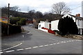
Up Canonbie Crescent, Aberfan
Canonbie Crescent ascends towards Pleasant View and Yr Hen Laethdy.
Image: © Jaggery
Taken: 27 Mar 2014
0.07 miles
4
Perthygleision houses, Aberfan
Viewed from Canonbie Crescent.
Image: © Jaggery
Taken: 27 Mar 2014
0.10 miles
5
Wires over Canonbie Crescent, Aberfan
Viewed looking north towards the street named Perthygleision.
Image: © Jaggery
Taken: 27 Mar 2014
0.11 miles
6
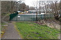
Path past a school perimeter fence, Aberfan
At the southern edge of Ysgol Rhyd y Grug.
Image: © Jaggery
Taken: 27 Mar 2014
0.11 miles
7
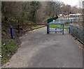
Metals barriers across a path near an Aberfan school
The school is Ysgol Rhyd y Grug.
Image: © Jaggery
Taken: 27 Mar 2014
0.12 miles
8
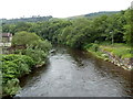
River Taff downstream from a footbridge between Merthyr Vale and Aberfan
Viewed from this footbridge. http://www.geograph.org.uk/photo/3025380 The Aberfan side is on the right.
Image: © Jaggery
Taken: 5 Jul 2012
0.12 miles
9
Remains of a railway bridge in Aberfan
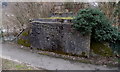
Between the street named Perthygleision and the River Taff.
Image: © Jaggery
Taken: 27 Mar 2014
0.13 miles
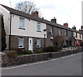
10
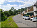
The view south along Bryn Taf, Aberfan
Looking south from the southern end of Kingsley Terrace/Rhes Kingsley. Bryn Taf is one of two streets (the other being Perthygleision) which trail their way south from the village centre along the valley side, pretty much following a contour. As a consequence, this view gives little impression of the steepness of the hillside.
For much of its length Bryn Taf is built up only on its uphill side. With the loss of almost all local industry, Aberfan's future would seem to be as a commuter dormitory - notice the recent residential development in the right foreground. According to a friend who lives locally, development on the downhill side of Bryn Taf seemed likely until the recent recession intervened.
Image: © Stefan Czapski
Taken: 20 Jun 2011
0.14 miles