1
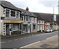
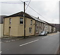
Commercial Place, Tyntetown
Viewed across the B4275. Commercial Place is between Halswell Street out of shot on the left and the corner of Bagot Street & Walsh Street on the right.
Image: © Jaggery
Taken: 6 Feb 2019
0.01 miles
2
Winkys corner shop, Tyntetown
On the corner of Halswell Street and Walsh Street.
Image: © Jaggery
Taken: 6 Feb 2019
0.02 miles
3
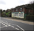
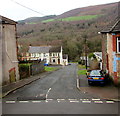
Derelict house on a Tyntetown corner
On the corner of Walsh Street and Bagot Street viewed in February 2019.
Image: © Jaggery
Taken: 6 Feb 2019
0.02 miles
4
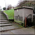
Walsh Street electricity substation, Tyntetown
The large cabinet is a Western Power Distribution electricity substation located on the south side of the B4275 opposite Walsh Street. The substation identifier is WALSH STREET S/S 552157.
Image: © Jaggery
Taken: 6 Feb 2019
0.02 miles
5
Junction of Halswell Street and the B4275, Tyntetown
Out of shot ahead, Halswell Street descends steeply northwards from
the B4275 Main Road to Bagot Street in the valley of the River Cynon.
Image: © Jaggery
Taken: 6 Feb 2019
0.02 miles
6
Former Matthewstown Mini Market, Tyntetown
Viewed across the B4275 in February 2019. The former mini market has been converted to residential use. An August 2011 Google Street View (taken when the mini market was open) shows only one door where now there are two doors. Matthewstown is the former name of the village now known as Tyntetown.
Image: © Jaggery
Taken: 6 Feb 2019
0.02 miles
7
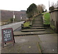
Steps up to a path from Tyntetown to Bryntirion
From the B4275 in Tyntetown. An electricity substation https://www.geograph.org.uk/photo/6052771 is on the right.
The white arrow on the blackboard points towards Winkys corner shop. https://www.geograph.org.uk/photo/6052770
Image: © Jaggery
Taken: 6 Feb 2019
0.02 miles
8
Row of houses, Main Road, Tyntetown
Extending for 45 metres along the north side of the B4275 Main Road from Milbourne Street to Halswell Street. The two street names are a reference to Halswell Milbourne Kemeys-Tynte who owned the estate on which the village was built.
Image: © Jaggery
Taken: 6 Feb 2019
0.03 miles
9
Bagot Street, Tyntetown
Descending from Walsh Street to Homerton Street and the valley of the River Cynon.
Image: © Jaggery
Taken: 6 Feb 2019
0.03 miles
10
Zebra crossing, Main Road, Tyntetown
Across the B4275 Main Road. The zigzag white lines indicate the no parking area near the zebra crossing.
Image: © Jaggery
Taken: 6 Feb 2019
0.04 miles


