IMAGES TAKEN NEAR TO
Abercynon Road, MOUNTAIN ASH, CF45 4XZ
Introduction
This page details the photographs taken nearby to Abercynon Road, CF45 4XZ by members of the Geograph project.
The Geograph project started in 2005 with the aim of publishing, organising and preserving representative images for every square kilometre of Great Britain, Ireland and the Isle of Man.

There are currently over 7.5m images from over14,400 individuals and you can help contribute to the project by visiting https://www.geograph.org.uk
Image Map
Images are licensed for reuse under creativecommons.org/licenses/by-sa/2.0
Notes
- Clicking on the map will re-center to the selected point.
- The higher the marker number, the further away the image location is from the centre of the postcode.
Image Listing (50 Images Found)
Images are licensed for reuse under creativecommons.org/licenses/by-sa/2.0
Image
Details
Distance
1

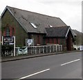
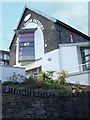
Former All Saints Church in Ynysboeth
Alongside the B4275 Abercynon Road. Coflein records that this building was All Saints Parish Church which was built in 1903 to serve the two communities of Matthewstown (the present-day Tyntetown) and Ynysboeth.
In February 2019 the two names at the entrance https://www.geograph.org.uk/photo/6055248 are The Feel Good Factory and Taffy's Cafe/Catering.
Image: © Jaggery
Taken: 6 Feb 2019
0.01 miles
2
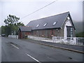
White-on-black nameboard in Ynysboeth
Viewed across the B4275 Abercynon Road. In February 2019 the nameboard shows The Feel Good Factory and Taffy's Cafe/Catering. This building used to be All Saints Parish Church, built in 1903 to serve the two communities of Matthewstown (the present-day Tyntetown) and Ynysboeth.
Image: © Jaggery
Taken: 6 Feb 2019
0.01 miles
3
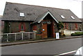
Entrance to the Feel Good Factory and Taffy's Cafe/Catering, Ynysboeth
From the B4275 Abercynon Road. This building used to be All Saints Parish Church, built in 1903 to serve the two communities of Matthewstown (the present-day Tyntetown) and Ynysboeth.
Image: © Jaggery
Taken: 6 Feb 2019
0.01 miles
4
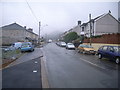
Ynysboeth - looking along main street
Image: © Nick Mutton 01329 000000
Taken: 23 Sep 2007
0.02 miles
5
The Feel Good Factory, Ynysboeth
This appears to be some kind of community church.
Image: © Nick Mutton 01329 000000
Taken: 23 Sep 2007
0.02 miles
7
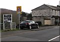
Warning sign School/Ysgol in Ynysboeth
Alongside the B4275 Abercynon Road on the approach to Ynysboeth Community Primary School.
Image: © Jaggery
Taken: 6 Feb 2019
0.02 miles
8
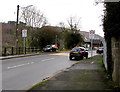
From 30 to 20 on Abercynon Road, Ynysboeth
The 30mph speed limit on the B4275 Abercynon Road drops to
20mph on the approach to Ynysboeth Community Primary School.
Image: © Jaggery
Taken: 6 Feb 2019
0.03 miles
9
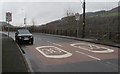
From 20 to 30 on the B4275 Abercynon Road, Ynysboeth
The 20mph speed limit near Ynysboeth Community Primary School increases to 30mph.
Image: © Jaggery
Taken: 6 Feb 2019
0.03 miles
10
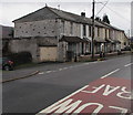
Hebron Villas, Ynysboeth
Row of six houses alongside the B4275 Abercynon Road.
Coflein records that Hebron Independent Chapel, built in 1902, used to be nearby.
Image: © Jaggery
Taken: 6 Feb 2019
0.05 miles