IMAGES TAKEN NEAR TO
Cemetery Road, ABERDARE, CF44 8HL
Introduction
This page details the photographs taken nearby to Cemetery Road, CF44 8HL by members of the Geograph project.
The Geograph project started in 2005 with the aim of publishing, organising and preserving representative images for every square kilometre of Great Britain, Ireland and the Isle of Man.

There are currently over 7.5m images from over14,400 individuals and you can help contribute to the project by visiting https://www.geograph.org.uk
Image Map
Images are licensed for reuse under creativecommons.org/licenses/by-sa/2.0
Notes
- Clicking on the map will re-center to the selected point.
- The higher the marker number, the further away the image location is from the centre of the postcode.
Image Listing (43 Images Found)
Images are licensed for reuse under creativecommons.org/licenses/by-sa/2.0
Image
Details
Distance
1
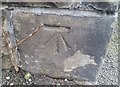
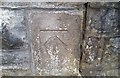
Ordnance Survey Cut Mark
This OS cut mark can be found on the wall of No15 Cemetery Road. It marks a point 165.994m above mean sea level.
Image: © Adrian Dust
Taken: 1 Jun 2017
0.05 miles
2
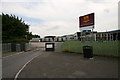
Aberdare Boys Comprehensive School
Aberdare Boys Comprehensive School on Cwmdare Road, Trecynon.
Image: © Darren W Rees
Taken: 24 Jul 2008
0.11 miles
3
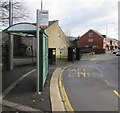
Cemetery Road bus stop and shelter, Trecynon, Aberdare
This stop for buses to Aberdare town centre and bus station is on the north side of the B4275 Cemetery Road near the corner of Potters Field. The bus stop sign shows Aberdare College which is about 200 metres behind the camera.
Image: © Jaggery
Taken: 11 Feb 2019
0.11 miles
4
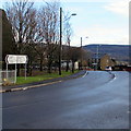
Cemetery Road towards Aberdare town centre
The sign pointing right along the B4275 Cemetery Road shows 1 mile to Aberdare town centre, 23 to Cardiff.
Image: © Jaggery
Taken: 31 Jan 2015
0.11 miles
5
Burger Express, 46 Cemetery Road, Trecynon, Aberdare
Viewed across the B4275 Cemetery Road in February 2019.
The name on the premises in a June 2011 Google Street View was Baguette Express.
Image: © Jaggery
Taken: 11 Feb 2019
0.11 miles
6
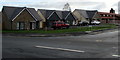
Y Dolydd, Aberdare
Y Dolydd is a cul-de-sac of recently-built houses on the SE side of Cwmdare Road viewed in February 2019.
Image: © Jaggery
Taken: 11 Feb 2019
0.13 miles
7
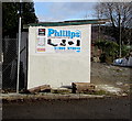
Phillips Monumental Sculptors direction sign, Aberdare
The turquoise arrow on the sign on Phillips Monumental Sculptors former premises points right towards their current premises in Park Monumental Works, Hirwaun Road, Trecynon.
Image: © Jaggery
Taken: 11 Feb 2019
0.13 miles
8
Ordnance Survey Cut Mark
This OS cut mark can be found on the wall post of Aberdare Park. It marks a point 162.507m above mean sea level.
Image: © Adrian Dust
Taken: 1 Jun 2017
0.13 miles
9
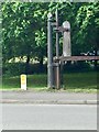
Level crossing gate support
This old structure is located where Cemetery Road crossed the railway branch line from Hirwaun to Cwm Dare.
Image: © Alan Hughes
Taken: 23 May 2019
0.14 miles
10
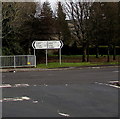
B4275 distance and direction signs facing the Cwmdare Road junction, Aberdare
Left along the B4275 Hirwaun Road for Penywaun (1 mile) and Hirwaun (2½)
Right along the B4275 Cemetery Road for Aberdare town centre (1 mile).
Also turn right here for Cardiff (23 miles).
Image: © Jaggery
Taken: 11 Feb 2019
0.15 miles