IMAGES TAKEN NEAR TO
Wellington Street, ABERDARE, CF44 8EN
Introduction
This page details the photographs taken nearby to Wellington Street, CF44 8EN by members of the Geograph project.
The Geograph project started in 2005 with the aim of publishing, organising and preserving representative images for every square kilometre of Great Britain, Ireland and the Isle of Man.

There are currently over 7.5m images from over14,400 individuals and you can help contribute to the project by visiting https://www.geograph.org.uk
Image Map
Images are licensed for reuse under creativecommons.org/licenses/by-sa/2.0
Notes
- Clicking on the map will re-center to the selected point.
- The higher the marker number, the further away the image location is from the centre of the postcode.
Image Listing (220 Images Found)
Images are licensed for reuse under creativecommons.org/licenses/by-sa/2.0
Image
Details
Distance
1
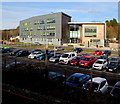
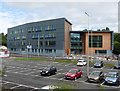
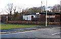
Coleg y Cymoedd Aberdare Campus
Viewed across Wellington Street from Aberdare railway station. Coleg y Cymoedd (College of the Valleys) is a further education college located at five main campuses in Rhondda Cynon Taf and Caerphilly County Borough. Coleg y Cymoedd was formed from the merger of Coleg Morgannwg and Ystrad Mynach College in September 2013.
Image: © Jaggery
Taken: 9 Jan 2019
0.01 miles
2
Aberdare RFC (Rugby Football Club)
View of Aberdare RFC (Rugby Football Club) from the footbridge near Ynys Swimming Pool, Aberdare.
Image: © Darren W Rees
Taken: 9 Apr 2003
0.02 miles
4
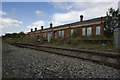
Old Aberdare High Level Railway Station
This is the old High Level Railway Station opened in 1851 on the Great Western Railway Neath to Pontypool Line.
Image: © Nick Earl
Taken: 15 Sep 2009
0.03 miles
5
Cambrian Lamp Works, Aberdare
Viewed across Wellington Street. The name board shows E Thomas & Williams Cambrian Lamp Works. An arrow on a circular sign points right towards Alwyn Rees Motor Body Repairs premises.
Stepping Stones day nursery http://www.geograph.org.uk/photo/3840733 is nearby.
Image: © Jaggery
Taken: 4 Feb 2014
0.04 miles
6
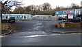
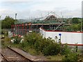
Redevelopment around the old Aberdare station
Image: © Gareth James
Taken: 14 May 2016
0.04 miles
7
Stepping Stones day nursery, Aberdare
Set back from Wellington Street, Stepping Stones is a purpose built
day nursery for children aged 6 weeks to 5 years.
Image: © Jaggery
Taken: 4 Feb 2014
0.05 miles
8
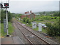
Aberdare (High Level) railway station (site), Mid Glamorgan
Opened in 1851 by the Vale of Neath Railway on the line from Swansea to Pontypool Road, this station closed in 1964. View north west from the new Aberdare station on what is now a freight-only line to Tower where, at the time of this image, the line ended. The old station had by now lost its canopy - compare to a 2000 view Image
Image: © Nigel Thompson
Taken: 28 May 2011
0.05 miles
9
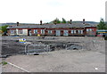
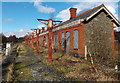
The original station building at Aberdare
Currently undergoing redevelopment.
Image: © Roger Cornfoot
Taken: 21 Aug 2017
0.05 miles
10
Former Aberdare (High Level) railway station
Located NW of the present-day (2014) station. http://www.geograph.org.uk/photo/3839105
The metal posts and frames used to support the canopy seen in this http://www.geograph.org.uk/photo/3305926 view taken in 2000.
Image: © Jaggery
Taken: 4 Feb 2014
0.05 miles