IMAGES TAKEN NEAR TO
Tegfan, FERNDALE, CF43 4TB
Introduction
This page details the photographs taken nearby to Tegfan, CF43 4TB by members of the Geograph project.
The Geograph project started in 2005 with the aim of publishing, organising and preserving representative images for every square kilometre of Great Britain, Ireland and the Isle of Man.

There are currently over 7.5m images from over14,400 individuals and you can help contribute to the project by visiting https://www.geograph.org.uk
Image Map
Images are licensed for reuse under creativecommons.org/licenses/by-sa/2.0
Notes
- Clicking on the map will re-center to the selected point.
- The higher the marker number, the further away the image location is from the centre of the postcode.
Image Listing (21 Images Found)
Images are licensed for reuse under creativecommons.org/licenses/by-sa/2.0
Image
Details
Distance
1
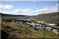
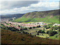
Looking across Highfield into Maerdy
A view from the mountain across Highfield and on towards Maerdy.
Image: © Alan Thomas
Taken: 2 Aug 2007
0.04 miles
2
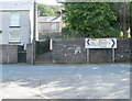
Two spelling mistakes in road sign, Ferndale
Viewed from an access road to an industrial estate. The sign shows the Welsh form of Aberdare as Aderdar instead of Aberdâr ( the b is reversed to a d and there is an accent missing from above the second a).
Image: © Jaggery
Taken: 11 May 2011
0.08 miles
3
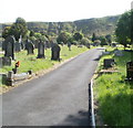
Ferndale Cemetery
A view along the central section of the cemetery, which is located on the south side of Highfield (the A4233), straddling the Ferndale/Maerdy boundary.
Image: © Jaggery
Taken: 11 May 2011
0.09 miles
5
Tarren y Maerdy
Edrych i lawr at fynwent o Darren y Maerdy.
Looking down on a burial ground from Tarren y Maerdy (trans. cliff of the dairy house).
Image: © Alan Richards
Taken: 1 Jul 2016
0.10 miles
7
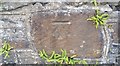
Ordnance Survey Cut Mark
This OS cut mark can be found on the cemetery wall. It marks a point 289.219m above mean sea level.
Image: © Adrian Dust
Taken: 16 Jun 2017
0.11 miles
8
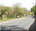
SE edge of Maerdy
The A4233 leaves Ferndale and enters Maerdy, a village of about 3,500 inhabitants.
Maerdy is at the head of the Rhondda Fach valley.
Image: © Jaggery
Taken: 11 May 2011
0.12 miles
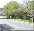
9
Walking to Ferndale
The walker is leaving Maerdy and entering Ferndale, along the A4233, here named Highfield.
Image: © Jaggery
Taken: 11 May 2011
0.12 miles
10
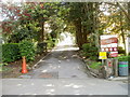
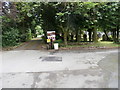
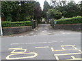
Entrance to Ferndale Cemetery
Viewed across the A4233, here named Highfield. The cemetery is partly in Ferndale and partly in Maerdy. One of the signs on the right warns of unsafe memorials.
Image: © Jaggery
Taken: 11 May 2011
0.12 miles