IMAGES TAKEN NEAR TO
Wind Street, FERNDALE, CF43 4PH
Introduction
This page details the photographs taken nearby to Wind Street, CF43 4PH by members of the Geograph project.
The Geograph project started in 2005 with the aim of publishing, organising and preserving representative images for every square kilometre of Great Britain, Ireland and the Isle of Man.

There are currently over 7.5m images from over14,400 individuals and you can help contribute to the project by visiting https://www.geograph.org.uk
Image Map
Images are licensed for reuse under creativecommons.org/licenses/by-sa/2.0
Notes
- Clicking on the map will re-center to the selected point.
- The higher the marker number, the further away the image location is from the centre of the postcode.
Image Listing (48 Images Found)
Images are licensed for reuse under creativecommons.org/licenses/by-sa/2.0
Image
Details
Distance
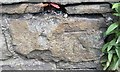
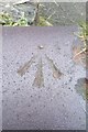
1
Ordnance Survey Cut Mark
This OS cut mark can be found on No28 Blaenllechau Road. It marks a point 262.686m above mean sea level.
Image: © Adrian Dust
Taken: 18 Jun 2017
0.02 miles
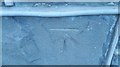
2
Ordnance Survey Cut Mark
This OS cut mark can be found on the wall east side of Commercial Street. It marks a point 234.818m above mean sea level.
Image: © Adrian Dust
Taken: 16 Jun 2017
0.04 miles
3
Ordnance Survey Rivet
This OS rivet can be found on the NE side of Commercial Street. It marks a point 239.984m above mean sea level.
Image: © Adrian Dust
Taken: 16 Jun 2017
0.05 miles
4
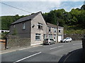
Bristol House and Boomerang House, Blaenllechau
Viewed across Station Road. The semi-detached houses are adjacent to the site of the demolished Ferndale railway station. Passenger services in this area ceased in 1964.
Image: © Jaggery
Taken: 20 Aug 2013
0.06 miles
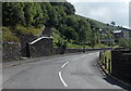
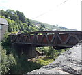
5
River bridge and a former railway bridge, Ferndale
The bridge in the foreground carries Station Road over a river, the Rhondda Fach. http://www.geograph.org.uk/photo/3612309
Behind the houses is another bridge http://www.geograph.org.uk/photo/3612408 now over a footpath and cycleway, which use the track bed of a dismantled railway line.
Image: © Jaggery
Taken: 20 Aug 2013
0.06 miles
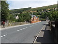
6
Bridge near the site of the demolished Ferndale railway station
Station Road crosses the bridge that used to be over the railway adjacent to Ferndale railway station, where passenger services ceased in 1964. The railway track bed is now part of a footpath and cycleway.
The village of Blaenllechau is ahead.
Image: © Jaggery
Taken: 20 Aug 2013
0.06 miles
7
Blaenllechau boundary sign
Viewed across Station Road. The Ferndale boundary sign is on the opposite side of the Blaenllechau boundary sign on the right. Blaenllechau is a small village in the Rhondda Fach valley in the county borough of Rhondda Cynon Taf.
Image: © Jaggery
Taken: 20 Aug 2013
0.06 miles
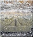
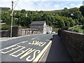
8
Ordnance Survey Rivet
This OS rivet can be found on the wall at the sharp bend in the road. It marks a point 224.491m above mean sea level.
Image: © Adrian Dust
Taken: 16 Jun 2017
0.06 miles
9
North side of Station Road bridge, Blaenllechau
The bridge carries Station Road over a footpath and cycleway, which use the track bed of a dismantled railway line. This location is adjacent to the site of the demolished Ferndale railway station. Passenger services in this area ceased in 1964.
Image: © Jaggery
Taken: 20 Aug 2013
0.07 miles
10
Ordnance Survey Cut Mark
This OS cut mark can be found on the north parapet of the railway bridge. It marks a point 217.109m above mean sea level.
Image: © Adrian Dust
Taken: 16 Jun 2017
0.07 miles