1
Madeline Street Pontygwaith
Viewed from near the corner of Baglan Street looking past the former St Mary Magdalene Church. http://www.geograph.org.uk/photo/3591047
Image: © Jaggery
Taken: 8 Aug 2013
0.01 miles
2
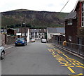
Down School Street, Pontygwaith
School Street descends past Pontygwaith Primary School http://www.geograph.org.uk/photo/3591180 on the right towards Madeline Street.
The bleak hillside was formerly part of an area of quarries and tips.
Image: © Jaggery
Taken: 8 Aug 2013
0.04 miles
3
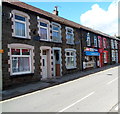
Pontygwaith Newsagents
R & LI Hughes, Newsagents, 76 Llewellyn Street, Pontygwaith.
Image: © Jaggery
Taken: 19 Sep 2012
0.04 miles
4
Ordnance Survey Cut Mark
This OS cut mark can be found on No92A Llewellyn Street. It marks a point 152.440m above mean sea level.
Image: © Adrian Dust
Taken: 18 Jun 2017
0.04 miles
5
Kieranz Kutz Barbers, Pontygwaith
Viewed across Llewellyn Street.
Image: © Jaggery
Taken: 20 Aug 2013
0.05 miles
6
Mostly Pound Shop, Pontygwaith
The shop at 72 Llewellyn Street has two names.
The nameboard shows R F John D.I.Y Fancy Goods. The banner above it shows Mostly £ Shop.
Image: © Jaggery
Taken: 19 Sep 2012
0.05 miles
7
Pontygwaith Community Centre
Viewed from an unnamed side road connecting Madeline Street behind the camera with Llewellyn Street ahead.
http://www.geograph.org.uk/photo/3587568 to a view across Llewellyn Street.
Image: © Jaggery
Taken: 8 Aug 2013
0.05 miles
8
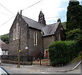
Former St Mary Magdalene Church Pontygwaith
Viewed across Madeline Street. The church, dating from the late 19th century, ceased to be used as a place of worship at the end of October 1997.
Image: © Jaggery
Taken: 8 Aug 2013
0.05 miles
9
Madeline St, Pontygwaith
Image: © John Lord
Taken: 6 Sep 2008
0.05 miles
10
Pontygwaith Primary School viewed from the west
Viewed from the corner of Graig Street looking across School Street. The school dates from 1895.
Image: © Jaggery
Taken: 8 Aug 2013
0.06 miles


