IMAGES TAKEN NEAR TO
Chepstow Road, TREORCHY, CF42 6UU
Introduction
This page details the photographs taken nearby to Chepstow Road, CF42 6UU by members of the Geograph project.
The Geograph project started in 2005 with the aim of publishing, organising and preserving representative images for every square kilometre of Great Britain, Ireland and the Isle of Man.

There are currently over 7.5m images from over14,400 individuals and you can help contribute to the project by visiting https://www.geograph.org.uk
Image Map
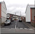
Images are licensed for reuse under creativecommons.org/licenses/by-sa/2.0
Notes
- Clicking on the map will re-center to the selected point.
- The higher the marker number, the further away the image location is from the centre of the postcode.
Image Listing (108 Images Found)
Images are licensed for reuse under creativecommons.org/licenses/by-sa/2.0
Image
Details
Distance
1
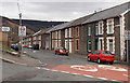
Clifton Street, Cwmparc
Clifton Street climbs away from Conway Road.
Image: © Jaggery
Taken: 4 Apr 2014
0.06 miles
2
Conway Road, Cwmparc
Looking towards Clifton Street.
Image: © Jaggery
Taken: 4 Apr 2014
0.07 miles
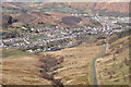
3
Treorchy
Looking up Rhondda Fawr. The Rhondda valleys were once best known for coal mining, but there are no collieries left there now.
Image: © Stephen McKay
Taken: Unknown
0.07 miles
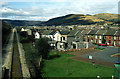
4
Bridgend District : Treorchy Scenery
Looking down towards the village of Treorchy.
Image: © Lewis Clarke
Taken: 23 Mar 2014
0.07 miles
5
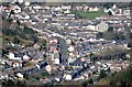
Bridgend District : Treorchy Scenery
Looking down to the town of Treorchy in the Rhondda Cynon Taff area.
Image: © Lewis Clarke
Taken: 23 Mar 2014
0.07 miles
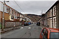
6
Narrow road to Clifton Street, Cwmparc
The wall and fence on the right are at the perimeter of Treorchy Comprehensive School.
The school entrance http://www.geograph.org.uk/photo/4077026 is nearby.
Image: © Jaggery
Taken: 4 Apr 2014
0.07 miles
7
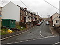
Chepstow Road, Cwmparc
Chepstow Road climbs away from the junction where Park Road to the west (left) becomes Park Crescent to the east.
Image: © Jaggery
Taken: 4 Apr 2014
0.07 miles
8
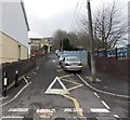
Conway Road, Cwmparc
Looking east from Castle Street. The road in the lower left corner is Chepstow Road. A 20mph speed limit applies along Conway Road on the approach to Treorchy Comprehensive School.
Image: © Jaggery
Taken: 4 Apr 2014
0.08 miles
9
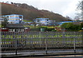
Treorchy Comprehensive School
A view from the A4061 across a bowling green looking towards the blue buildings of Treorchy Comprehensive School.
Image: © Jaggery
Taken: 23 Jan 2012
0.09 miles
10
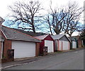
Lockup garages and bare trees, Conway Road, Cwmparc
The trees are leafless in early April.
Image: © Jaggery
Taken: 4 Apr 2014
0.09 miles