IMAGES TAKEN NEAR TO
Hermon Street, TREORCHY, CF42 6PW
Introduction
This page details the photographs taken nearby to Hermon Street, CF42 6PW by members of the Geograph project.
The Geograph project started in 2005 with the aim of publishing, organising and preserving representative images for every square kilometre of Great Britain, Ireland and the Isle of Man.

There are currently over 7.5m images from over14,400 individuals and you can help contribute to the project by visiting https://www.geograph.org.uk
Image Map
Images are licensed for reuse under creativecommons.org/licenses/by-sa/2.0
Notes
- Clicking on the map will re-center to the selected point.
- The higher the marker number, the further away the image location is from the centre of the postcode.
Image Listing (23 Images Found)
Images are licensed for reuse under creativecommons.org/licenses/by-sa/2.0
Image
Details
Distance
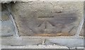
1
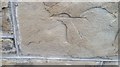
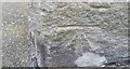
Ordnance Survey Cut Mark
This damaged OS cut mark can be found on No119 High Street. It marks a point 159.724m above mean sea level.
Image: © Adrian Dust
Taken: 7 May 2017
0.03 miles
2
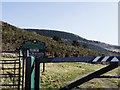
Tyn Y Bedw
The start of a walk taking you through a scenic walk with wonderful views. If you have the energy you can walk to a peak about 481 metres above sea level. This site is reclaimed land from British Coal.
Image: © Derek Cummings
Taken: 14 Feb 2010
0.08 miles
3
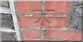
Ordnance Survey Cut Mark
This OS cut mark can be found on No55 High Street. It marks a point 157.545m above mean sea level.
Image: © Adrian Dust
Taken: 7 May 2017
0.10 miles
4
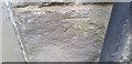
Ordnance Survey Cut Mark
This OS cut mark can be found on No103 High Street. It marks a point 158.972m above mean sea level.
Image: © Adrian Dust
Taken: 7 May 2017
0.13 miles
5
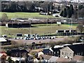
Treorchy Rugby
Taken with a zoom lens looking down from Tyn y Bedw country park this shows the activity on a Sunday morning at the Rugby ground below.
Image: © Derek Cummings
Taken: 14 Feb 2010
0.14 miles
6
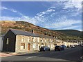
High Street, Treorchy
View along High Street, Treorchy, with Mynydd yr Eglwys in the distance.
Image: © Alan Hughes
Taken: 30 Oct 2017
0.15 miles
7
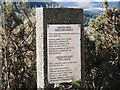
Mine shaft monument
The plaque to one of the shafts that used to litter this area before its transformation by the forestry commission. The text is clear to read.
Image: © Derek Cummings
Taken: 14 Feb 2010
0.16 miles
8
Ordnance Survey Cut Mark
This OS cut mark can be found on No65 Prospect Place. It marks a point 163.205m above mean sea level.
Image: © Adrian Dust
Taken: 7 May 2017
0.20 miles
9
Ordnance Survey Cut Mark
This OS cut mark can be found on The Griffin PH. It marks a point 157.109m above mean sea level.
Image: © Adrian Dust
Taken: 7 May 2017
0.20 miles
10
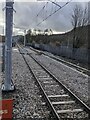
Rhondda Line SE of Treorchy station
Viewed from the SE end of the single platform at Treorchy station in March 2024.
Next station ahead is Ton Pentre.
Image: © Jaggery
Taken: 1 Mar 2024
0.21 miles