IMAGES TAKEN NEAR TO
Cardiff Street, TREORCHY, CF42 6BG
Introduction
This page details the photographs taken nearby to Cardiff Street, CF42 6BG by members of the Geograph project.
The Geograph project started in 2005 with the aim of publishing, organising and preserving representative images for every square kilometre of Great Britain, Ireland and the Isle of Man.

There are currently over 7.5m images from over14,400 individuals and you can help contribute to the project by visiting https://www.geograph.org.uk
Image Map
Images are licensed for reuse under creativecommons.org/licenses/by-sa/2.0
Notes
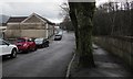
- Clicking on the map will re-center to the selected point.
- The higher the marker number, the further away the image location is from the centre of the postcode.
Image Listing (182 Images Found)
Images are licensed for reuse under creativecommons.org/licenses/by-sa/2.0
Image
Details
Distance
1
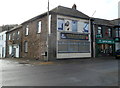
Treorchy RAFA branch
The Royal Air Force Association branch is on the corner of Bute Street and Clark Street. On the right are the premises of Parish, Green & Coleman, opticians.
Image: © Jaggery
Taken: 23 Jan 2012
0.02 miles
2
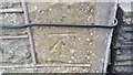
Ordnance Survey Cut Mark
This OS cut mark can be found on No28 Cardiff Street. It marks a point 163.723m above mean sea level.
Image: © Adrian Dust
Taken: 28 Apr 2017
0.05 miles
3
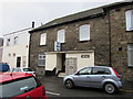
Cardiff Street, Treorchy
From the A4061 Bute Street along Cardiff Street towards River Terrace above the Rhondda River.
Image: © Jaggery
Taken: 9 Apr 2018
0.05 miles
4
The RAFA pub, Treorchy
The Clark Street side of the pub at 137 Bute Street viewed in March 2020.
The name in view in 2012 was Treorchy RAFA branch. https://www.geograph.org.uk/photo/2790354
Image: © Jaggery
Taken: 14 Mar 2020
0.05 miles
5
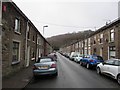
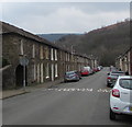
Clark Street, Treorchy
Looking to the SSW along Clark Street towards River Terrace.
Image: © Jaggery
Taken: 14 Mar 2020
0.06 miles
6
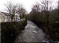
Downstream along the Rhondda River, Treorchy
Viewed from this https://www.geograph.org.uk/photo/6417808 bridge. The houses are in River Terrace.
Image: © Jaggery
Taken: 14 Mar 2020
0.06 miles
7
Maximum Height 7" 0' (2.1m), Treorchy
On the wall in the background here https://www.geograph.org.uk/photo/6416522 on the approach to Clark Street.
Image: © Jaggery
Taken: 14 Mar 2020
0.06 miles
8
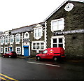
Royal Mail van parked outside the White Dragon, Treorchy
On the Cardiff Street side of the White Dragon on the corner of Bute Street.
Image: © Jaggery
Taken: 14 Mar 2020
0.06 miles
9
SE along River Terrace, Treorchy
Looking to the southeast along River Terrace from near the Windsor Street junction.
The wall on the right is above the Rhondda River.
Image: © Jaggery
Taken: 14 Mar 2020
0.06 miles
10
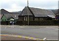
St Matthew's Church, Treorchy
Located on the corner of Bute Street and Cardiff Street, St Matthew's is in the Church in Wales Diocese of Llandaff. https://www.geograph.org.uk/photo/5733413 to the information board on the right. Coflein records that the building was erected in 1871 as a National School. It is shown on the first edition Ordnance Survey 25" map as School (Boys and Girls). By 1900 it is annotated Church, by which time the rectangular building had the addition of an apse. The corrugated iron hall on the left dates from the early 20th century.
Image: © Jaggery
Taken: 9 Apr 2018
0.06 miles