IMAGES TAKEN NEAR TO
Oakfield Terrace, TONYPANDY, CF40 2TE
Introduction
This page details the photographs taken nearby to Oakfield Terrace, CF40 2TE by members of the Geograph project.
The Geograph project started in 2005 with the aim of publishing, organising and preserving representative images for every square kilometre of Great Britain, Ireland and the Isle of Man.

There are currently over 7.5m images from over14,400 individuals and you can help contribute to the project by visiting https://www.geograph.org.uk
Image Map
Images are licensed for reuse under creativecommons.org/licenses/by-sa/2.0
Notes
- Clicking on the map will re-center to the selected point.
- The higher the marker number, the further away the image location is from the centre of the postcode.
Image Listing (93 Images Found)
Images are licensed for reuse under creativecommons.org/licenses/by-sa/2.0
Image
Details
Distance
1
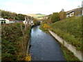
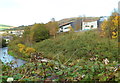
Rhondda Fawr river upstream from Princess Louise Road, Llwynypia
The Rhondda Fawr flows towards the bridge carrying the A4058, here named Princess Louise Road, over the river. On the right is an edge of a new hospital, Ysbyty Cwm Rhondda. http://www.geograph.org.uk/photo/2791402
Image: © Jaggery
Taken: 28 Oct 2011
0.03 miles
2
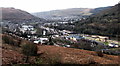
Llwynypia viewed from Penrhys Road, Ystrad
Llwynypia is built on flattish land in the valley of the Rhondda Fawr river.
The grey river between trees can be seen near the centre of the view.
Image: © Jaggery
Taken: 30 Mar 2015
0.04 miles
3
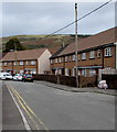
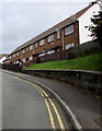
Two rows of houses, Bryn Ivor Street, Llwynypia
Bryn Ivor Street is a dead end street extending for nearly 300 metres from the A4058 Salem Terrace.
Image: © Jaggery
Taken: 2 Oct 2017
0.04 miles
4
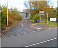
Princess Louise Road entrance to Ysbyty Cwm Rhondda
This entrance at the southern edge of the hospital is for goods delivery vehicles and emergency vehicles only. There is also a path for pedestrians. The main hospital entrance is from Partridge Road. http://www.geograph.org.uk/photo/2791402
Image: © Jaggery
Taken: 28 Oct 2011
0.06 miles
5
A glimpse of Ysbyty Cwm Rhondda viewed across the Rhondda Fawr river
Viewed from the brambly edge of the A4058. On the right is an edge of the recently-built Ysbyty Cwm Rhondda hospital http://www.geograph.org.uk/photo/2791402. The Rhondda Fawr river is on the left.
Image: © Jaggery
Taken: 28 Oct 2011
0.06 miles
6
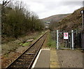
Rhondda Line north from Llwynypia railway station
Towards Ystrad Rhondda station, 1 mile (1.6km) ahead.
Image: © Jaggery
Taken: 30 Mar 2015
0.07 miles
7
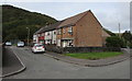
Row of houses, Bryn Ivor Street, Llwynypia
On the west side of the main north-south alignment of Bryn Ivor Street.
Image: © Jaggery
Taken: 2 Oct 2017
0.08 miles
8
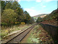
Rhondda Line heads north away from Llwynypia station
Viewed from the northern edge of the station platform. The next station is this direction is Ystrad Rhondda.
Image: © Jaggery
Taken: 28 Oct 2011
0.08 miles
9
Row of houses above Bryn Ivor Street, Llwynypia
Bryn Ivor Street is a dead end street extending for nearly 300 metres from the A4058 Salem Terrace.
Image: © Jaggery
Taken: 2 Oct 2017
0.08 miles
10
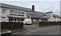
Bryn Ivor, Bryn Ivor Street, Llwynypia
Bryn Ivor is extra care housing for the elderly.
Image: © Jaggery
Taken: 2 Oct 2017
0.09 miles