1
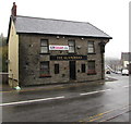
East side of The Glamorgan, Brook Street, Williamstown
The Glamorgan bar & grill is alongside a bend in the B4278. http://www.geograph.org.uk/photo/5581296 to the north side of The Glamorgan.
Image: © Jaggery
Taken: 26 Oct 2017
0.00 miles
2
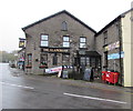
YT's Plaice in Williamstown
Fish & chips takeaway located in London House, Brook Street, Williamstown.
Image: © Jaggery
Taken: 26 Oct 2017
0.00 miles
3
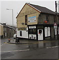
Williamstown fish & chips
Image: © Gareth James
Taken: 2 Jan 2015
0.01 miles
4
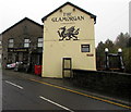
North side of The Glamorgan, Brook Street, Williamstown
This side of the Glamorgan bar & grill is opposite the Cornwall Road junction.
http://www.geograph.org.uk/photo/5581293 to the east side of The Glamorgan.
Image: © Jaggery
Taken: 26 Oct 2017
0.01 miles
5
Cornwall Road houses, Williamstown
At the southern end of Cornwall Road viewed from the corner of Brook Street.
Image: © Jaggery
Taken: 26 Oct 2017
0.01 miles
6
A4119 distances from Williamstown
Signs at the B4278 junction show Tonypandy 2 (miles) Edmondstown ½ Penygraig ½ Dinas 1½ Porth 2¼.
The upper circular sign sign indicates Clearway (no stopping or parking).
The lower circular sign indicates No Pedestrians.
Image: © Jaggery
Taken: 3 Nov 2017
0.02 miles
7
Black dragon depiction on a Brook Street wall, Williamstown
On a wall of the Glamorgan bar & grill. http://www.geograph.org.uk/photo/5581296
Image: © Jaggery
Taken: 26 Oct 2017
0.02 miles
8
BT phonebox, Brook Street, Williamstown
Located here http://www.geograph.org.uk/photo/5581300 outside the Glamorgan bar & grill.
Image: © Jaggery
Taken: 26 Oct 2017
0.02 miles
9
Former Williamstown Post Office
In October 2017, the Williamstown Post Office name sign remains on the building on the corner of Brook Street and Cornwall Road, now the premises of Coffee @ Cafe which sells coffee and hot or cold food. The current village post office is inside Quick Stop http://www.geograph.org.uk/photo/5579970 at 28-30 Brook Street.
Image: © Jaggery
Taken: 26 Oct 2017
0.02 miles
10
A4119 from Williamstown towards Tonypandy
A nearby sign http://www.geograph.org.uk/photo/5620701 shows Tonypandy 2 (miles).
The upper sign on the left indicates Clearway (no stopping or parking).
The lower sign indicates No Pedestrians.
Image: © Jaggery
Taken: 3 Nov 2017
0.03 miles


