IMAGES TAKEN NEAR TO
Caemawr Gardens, PORTH, CF39 9DB
Introduction
This page details the photographs taken nearby to Caemawr Gardens, CF39 9DB by members of the Geograph project.
The Geograph project started in 2005 with the aim of publishing, organising and preserving representative images for every square kilometre of Great Britain, Ireland and the Isle of Man.

There are currently over 7.5m images from over14,400 individuals and you can help contribute to the project by visiting https://www.geograph.org.uk
Image Map
Images are licensed for reuse under creativecommons.org/licenses/by-sa/2.0
Notes
- Clicking on the map will re-center to the selected point.
- The higher the marker number, the further away the image location is from the centre of the postcode.
Image Listing (73 Images Found)
Images are licensed for reuse under creativecommons.org/licenses/by-sa/2.0
Image
Details
Distance
2
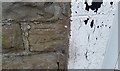
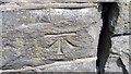
Ordnance Survey Cut Mark
This OS cut mark can be found on No20 Cymmer Road. It marks a point 100.261m above mean sea level.
Image: © Adrian Dust
Taken: 27 May 2018
0.06 miles
3
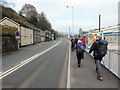
Heol y Cymer / Cymmer Road
Cerddwyr yn dilyn Heol y Cymer.
Walkers following Cymmer Road (trans. [river] confluence).
Image: © Alan Richards
Taken: 7 Apr 2019
0.07 miles
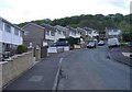
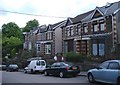
4
Caemawr Road houses, Porth
Viewed from near the Cymmer Road junction.
Image: © Jaggery
Taken: 30 Jul 2014
0.14 miles
5
Ordnance Survey Cut Mark
This OS cut mark can be found on the wall north side of Cemetery Road. It marks a point 107.637m above mean sea level.
Image: © Adrian Dust
Taken: 24 Jun 2017
0.14 miles
7
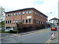
Porth Police Station
Located on Porth Street (B4278). The £1.3 million station was built on a site once occupied by the Victorian police station, which had stood for more than a century. The new station was opened in July 2005. Porth is served by the South Wales Police, northern division (Merthyr Tydfil and Rhondda Cynon Taf).
Image: © Jaggery
Taken: 6 May 2011
0.17 miles
8
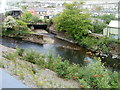
Confluence of the Rhonddas, Porth
The Rhondda Fawr (Big Rhondda), from the left edge of the view, meets the Rhondda Fach (Little Rhondda) in Porth, adjacent to the Rheola Bridge, http://www.geograph.org.uk/photo/2612363 part of which is in the upper left corner of the view. The merged rivers continue on the right as the Rhondda River.
Image: © Jaggery
Taken: 6 May 2011
0.17 miles
9
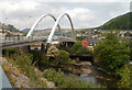
Rheola Bridge, Porth
The Rheola Bridge was made with 1,100 tonnes of structural steel. It crosses the Rhondda River at the confluence of the two Rhonddas, http://www.geograph.org.uk/photo/2612325 and the Rhondda Line railway. It was built as part of the £98 million Porth relief road project, and is one of 11 bridges that were built or replaced during the project. The relief road was opened to traffic in December 2006. Landscaping continued into 2007.
Image: © Jaggery
Taken: 6 May 2011
0.17 miles
10
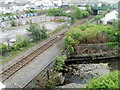
Rhondda Line railway crosses the Rhondda Fach, Porth
Viewed from Rheola Bridge. http://www.geograph.org.uk/photo/2612372
The single-track railway line crosses the Rhondda Fach (Little Rhondda) river a few metres from its confluence http://www.geograph.org.uk/photo/2612325 with the Rhondda Fawr (Big Rhondda), forming the Rhondda River.
Image: © Jaggery
Taken: 6 May 2011
0.17 miles