IMAGES TAKEN NEAR TO
Heol Heulog, PORTH, CF39 8RN
Introduction
This page details the photographs taken nearby to Heol Heulog, CF39 8RN by members of the Geograph project.
The Geograph project started in 2005 with the aim of publishing, organising and preserving representative images for every square kilometre of Great Britain, Ireland and the Isle of Man.

There are currently over 7.5m images from over14,400 individuals and you can help contribute to the project by visiting https://www.geograph.org.uk
Image Map
Images are licensed for reuse under creativecommons.org/licenses/by-sa/2.0
Notes
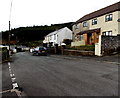
- Clicking on the map will re-center to the selected point.
- The higher the marker number, the further away the image location is from the centre of the postcode.
Image Listing (87 Images Found)
Images are licensed for reuse under creativecommons.org/licenses/by-sa/2.0
Image
Details
Distance
1
Heol y Derw, Evanstown
A street on the SW side of Coronation Road.
Image: © Jaggery
Taken: 11 Apr 2014
0.02 miles
2
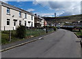
Heol-y-Parc, Gilfach Goch
Street on the east side of Glannant Road.
Image: © Jaggery
Taken: 11 Apr 2014
0.03 miles
3
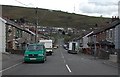
Evanstown in the distance
Taken from just south of the junction of High St and Coronation Rd
Image: © John Lord
Taken: 12 Sep 2008
0.04 miles
4
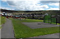
Sports court, Gilfach Goch
On the south side of Heol-y-Parc.
Image: © Jaggery
Taken: 11 Apr 2014
0.04 miles
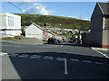
5
Unclassified SW end of Abercerdin Road, Evanstown
Behind the camera, Abercerdin Road is part of the B4564. The curved white line in the foreground marks the course of the B4564, which is renamed Coronation Road beyond the left edge of the view.
The unclassified Abercerdin Road ahead descends towards Gilfach Goch Welfare Park.
Image: © Jaggery
Taken: 11 Apr 2014
0.05 miles
6
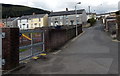
Road from Gilfach Goch Welfare Park to Heol-y-Parc
The road passes the edge of a children's play area. http://www.geograph.org.uk/photo/4528143 The houses are at the eastern end of Heol-y-Parc.
Image: © Jaggery
Taken: 11 Apr 2014
0.05 miles
7
Road junction Evanstown.
Looking down the B4564 towards Gilfach Goch, with the Evanstown Community Centre in the left foreground.
Image: © Colin Pyle
Taken: 22 Aug 2008
0.05 miles
8
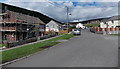
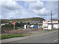
Glannant Road, Gilfach Goch
The Heol-y-Parc junction is on the right.
Image: © Jaggery
Taken: 11 Apr 2014
0.05 miles
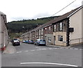
9
Coronation Road, Evanstown
Viewed from the Kenry Street junction, where the B4564 Abercerdin Road turns through 90 degrees and is renamed the B4564 Coronation Road.
Image: © Jaggery
Taken: 11 Apr 2014
0.06 miles
10
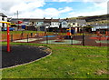
Children's play area, Gilfach Goch
On the south side of Heol-y-Parc.
Image: © Jaggery
Taken: 11 Apr 2014
0.06 miles