IMAGES TAKEN NEAR TO
Dewi Street, PONTYPRIDD, CF37 4RB
Introduction
This page details the photographs taken nearby to Dewi Street, CF37 4RB by members of the Geograph project.
The Geograph project started in 2005 with the aim of publishing, organising and preserving representative images for every square kilometre of Great Britain, Ireland and the Isle of Man.

There are currently over 7.5m images from over14,400 individuals and you can help contribute to the project by visiting https://www.geograph.org.uk
Image Map
Images are licensed for reuse under creativecommons.org/licenses/by-sa/2.0
Notes
- Clicking on the map will re-center to the selected point.
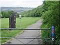
- The higher the marker number, the further away the image location is from the centre of the postcode.
Image Listing (15 Images Found)
Images are licensed for reuse under creativecommons.org/licenses/by-sa/2.0
Image
Details
Distance
2
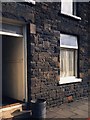
Bin Day on Coedpenmaen Rd
... 106 Coedpenmean Rd. The bin emptied, we're ready to go again.
Image: © Ian T
Taken: 24 May 1986
0.14 miles

4
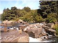
Waterfall on the Taff upstream of the disused railway bridge
View is of a waterfall on the river Taff north of the centre of Pontypridd and is used for paddling and picnicking in the summer.
Image: © nantcoly
Taken: 17 Jul 2005
0.16 miles
5
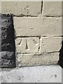
Ordnance Survey Cut Mark
This OS cut mark can be found on Norton Court (the Old Bassett Arms). It marks a point 86.640m above mean sea level.
Image: © Adrian Dust
Taken: 23 Apr 2016
0.17 miles
6
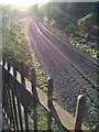
Railway Line
Abercynon to Pontypridd railway line at Craig yr Hesg.
Image: © Alan Hughes
Taken: 28 Nov 2016
0.17 miles
7
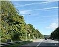
Unprotected lay-by by A470, Pontypridd
As this small lay-by has an emergency phone, one assumes it is intended for emergencies only, not for picnics
Image: © David Smith
Taken: 17 Sep 2022
0.18 miles

9
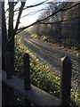
Railway Line
Abercynon to Pontypridd railway line.
Image: © Alan Hughes
Taken: 28 Nov 2016
0.18 miles
10
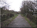
Taff Trail near Pontypridd
An old railway bridge which used to carry the Pont Shon Norton Branch of the Taff Vale Railway. Now the Taff Trail uses this route. The trail turns left after the bridge and heads up towards Coedpenmaen Road.
Image: © John Light
Taken: 4 Jan 2013
0.18 miles