IMAGES TAKEN NEAR TO
Great Street, PONTYPRIDD, CF37 2NE
Introduction
This page details the photographs taken nearby to Great Street, CF37 2NE by members of the Geograph project.
The Geograph project started in 2005 with the aim of publishing, organising and preserving representative images for every square kilometre of Great Britain, Ireland and the Isle of Man.

There are currently over 7.5m images from over14,400 individuals and you can help contribute to the project by visiting https://www.geograph.org.uk
Image Map
Images are licensed for reuse under creativecommons.org/licenses/by-sa/2.0
Notes
- Clicking on the map will re-center to the selected point.
- The higher the marker number, the further away the image location is from the centre of the postcode.
Image Listing (51 Images Found)
Images are licensed for reuse under creativecommons.org/licenses/by-sa/2.0
Image
Details
Distance
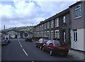
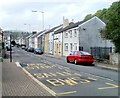
2
Trehafod Road, Trehafod
Looking east.
Image: © Roger Cornfoot
Taken: 25 Apr 2007
0.01 miles
3
Colliery Street, Trehafod
Viewed from the edge of a River Rhondda footbridge. http://www.geograph.org.uk/photo/2396817
Image: © Jaggery
Taken: 6 May 2011
0.02 miles
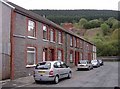
4
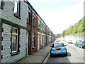
Fountain Street, Trehafod
Street at the NE edge of Trehafod. All the houses are on one side of the street, facing the wall at the edge of the A4058. Hafod (railway) Junction was formerly nearby.
Image: © Jaggery
Taken: 6 May 2011
0.02 miles
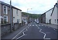
5
Trehafod Road, Trehafod
Trehafod Road heads west towards the centre of the village. Trehafod is in the Rhondda Valley between Porth and Pontypridd.
Image: © Jaggery
Taken: 6 May 2011
0.02 miles
6
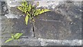
Ordnance Survey Cut Mark
This OS cut mark can be found on the wall of No102 Trehafod Road. It marks a point 71.604m above mean sea level.
Image: © Adrian Dust
Taken: 24 Jun 2017
0.03 miles
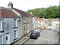
7
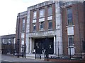
Trehafod Memorial Hall and Institute
Image: © Roger Cornfoot
Taken: 25 Apr 2007
0.04 miles
9
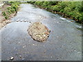
River Rhondda downstream from a footbridge, Trehafod
Viewed from a footbridge. http://www.geograph.org.uk/photo/2396817
http://www.geograph.org.uk/photo/2396842 to a view upstream.
After a prolonged dry spell through March and April, the Rhondda is at a low level in this view taken on May 6th 2011.
Image: © Jaggery
Taken: 6 May 2011
0.04 miles
10
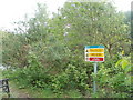
Danger sign, Trehafod
A sign, in English and Welsh, on the north bank of the River Rhondda warns
DANGER - VERTICAL DROP
DANGER - DEEP WATER
NO SWIMMING
The sign is near the eastern border of Trehafod, close to Trehafod Road.
Image: © Jaggery
Taken: 6 May 2011
0.04 miles