IMAGES TAKEN NEAR TO
Colliery Street, PONTYPRIDD, CF37 2NB
Introduction
This page details the photographs taken nearby to Colliery Street, CF37 2NB by members of the Geograph project.
The Geograph project started in 2005 with the aim of publishing, organising and preserving representative images for every square kilometre of Great Britain, Ireland and the Isle of Man.

There are currently over 7.5m images from over14,400 individuals and you can help contribute to the project by visiting https://www.geograph.org.uk
Image Map
Images are licensed for reuse under creativecommons.org/licenses/by-sa/2.0
Notes
- Clicking on the map will re-center to the selected point.
- The higher the marker number, the further away the image location is from the centre of the postcode.
Image Listing (44 Images Found)
Images are licensed for reuse under creativecommons.org/licenses/by-sa/2.0
Image
Details
Distance
1
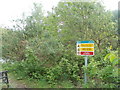
Danger sign, Trehafod
A sign, in English and Welsh, on the north bank of the River Rhondda warns
DANGER - VERTICAL DROP
DANGER - DEEP WATER
NO SWIMMING
The sign is near the eastern border of Trehafod, close to Trehafod Road.
Image: © Jaggery
Taken: 6 May 2011
0.01 miles
2
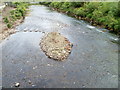
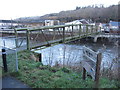
River Rhondda downstream from a footbridge, Trehafod
Viewed from a footbridge. http://www.geograph.org.uk/photo/2396817
http://www.geograph.org.uk/photo/2396842 to a view upstream.
After a prolonged dry spell through March and April, the Rhondda is at a low level in this view taken on May 6th 2011.
Image: © Jaggery
Taken: 6 May 2011
0.01 miles
3
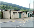
Trehafod Storm sewage pumping station
Located between Trehafod Road and the north bank of the River Rhondda. There have been several major floods of the Rhondda in this area. The most serious one in the last century was in 1960, when one man drowned.
Image: © Jaggery
Taken: 6 May 2011
0.01 miles
4
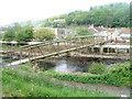
Footbridge across the Rhondda River in Trehafod
Image: © Gareth James
Taken: 4 Apr 2015
0.03 miles
5
Footbridge across the Rhondda River in Trehafod
Image: © Gareth James
Taken: 2 Jan 2015
0.03 miles
7
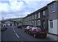
Trehafod Road, Trehafod
Looking east.
Image: © Roger Cornfoot
Taken: 25 Apr 2007
0.04 miles
8
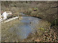
Footbridge across the River Rhondda, Trehafod
The footbridge connects the western edge of Barry Sidings Country Park, with Colliery Street on the north bank of the Rhondda.
Image: © Jaggery
Taken: 6 May 2011
0.06 miles
9
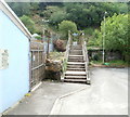
Steps to a footbridge, Colliery Street, Trehafod
The steps lead up to a footbridge http://www.geograph.org.uk/photo/2396817 across the River Rhondda.
Image: © Jaggery
Taken: 6 May 2011
0.06 miles
10
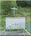
Riverside walk direction sign, Trehafod
At the southern end of a River Rhondda footbridge http://www.geograph.org.uk/photo/2396817 a sign points left for Pontypridd (1¾) Rhydyfelin (4) and Abercynon (6), right for Trehafod and Rhondda Heritage Park (¼)
and Porth (1½). Distances are in miles.
Image: © Jaggery
Taken: 6 May 2011
0.06 miles