IMAGES TAKEN NEAR TO
Cross Street, PONTYPRIDD, CF37 2LP
Introduction
This page details the photographs taken nearby to Cross Street, CF37 2LP by members of the Geograph project.
The Geograph project started in 2005 with the aim of publishing, organising and preserving representative images for every square kilometre of Great Britain, Ireland and the Isle of Man.

There are currently over 7.5m images from over14,400 individuals and you can help contribute to the project by visiting https://www.geograph.org.uk
Image Map
Images are licensed for reuse under creativecommons.org/licenses/by-sa/2.0
Notes
- Clicking on the map will re-center to the selected point.
- The higher the marker number, the further away the image location is from the centre of the postcode.
Image Listing (73 Images Found)
Images are licensed for reuse under creativecommons.org/licenses/by-sa/2.0
Image
Details
Distance
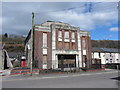
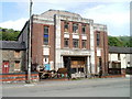
3
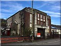
Trehafod Memorial Hall and Institute
Trehafod Community Hall - note the deterioration when you compare Image taken two years ago.
Image: © Alan Hughes
Taken: 9 Mar 2017
0.04 miles
4
The former Trehafod Memorial Hall and Institute
Image: © Gareth James
Taken: 4 Apr 2015
0.04 miles
5

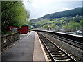
The view east from Trehafod railway station
Looking in the direction of Pontypridd station, along the Rhondda Line route operated by Arriva Trains Wales.
Image: © Jaggery
Taken: 6 May 2011
0.04 miles
6
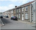
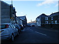
Morgannwg Street, Trehafod
Houses on the north side of Morgannwg Street, which runs almost exactly east to west. The far end of the street connects with Cross Street.
Image: © Jaggery
Taken: 6 May 2011
0.04 miles
7
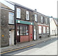
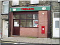
Former Trehafod post office
Located at 110 Trehafod Road. The disappearance of the name of the post office, which had begun in this view http://www.geograph.org.uk/photo/1217341 is now complete.
A Post Office notice on a window states:
"Following a local public consultation process we have recently announced the decision to close this branch as part of a national Network Change Programme. We can confirm that this branch will close on the following date:
Friday 29th February 2008
We do hope that you continue to use the alternative branches in your area, please see the decision poster for full details on the locations and services."
The Edward VII postbox http://www.geograph.org.uk/photo/2397422 in the wall is in very good condition and looks like it was recently repainted.
Image: © Jaggery
Taken: 6 May 2011
0.04 miles
8
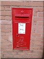
Edward VII postbox, Trehafod
The recently-painted postbox is in the wall of the former Trehafod post office http://www.geograph.org.uk/photo/2397418 which closed at the end of February 2008.
Image: © Jaggery
Taken: 6 May 2011
0.04 miles
9
Former Trehafod Memorial Hall & Institute
Despite its Grade II listing, this once grand building on Trehafod Road is now an eyesore, with a pile of junk visible behind the railings, and a general appearance of decay.
Image: © Jaggery
Taken: 6 May 2011
0.04 miles