1
Former Oddfellows Hall, Treforest
The house on the corner of Bridge Street and Old Park Terrace bears the stone inscription ODDFELLOWS HALL BUILT A.D. 1848.
Image: © Jaggery
Taken: 9 Dec 2011
0.02 miles
2
Vinnys Supermarket, Treforest
Formerly a Spar store, Vinnys may not be many people's idea of a supermarket!
Located on Queen Street at the Y-junction with Princess Street and New Park Crescent.
Image: © Jaggery
Taken: 9 Dec 2011
0.02 miles
3
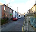
Old Park Terrace Treforest
Looking north from New Park Terrace http://www.geograph.org.uk/photo/3831255.
Image: © Jaggery
Taken: 30 Jan 2014
0.05 miles
4
Kiss Shot Pool Club, Treforest
Located on the corner of Park Street and Fothergill Street. The large rectangular window contains a depiction of a pool ball, an 8-ball. The entrance is from Fothergill Street, on the right.
Image: © Jaggery
Taken: 9 Dec 2011
0.05 miles
5
Saron chapel, Treforest
Saron Welsh Calvinistic Methodist Chapel is located at the southern end of Saron Street. The Welsh in its name refers to the language used in the chapel. A translation of the Welsh inscription in stone above the middle window shows that the chapel was built in 1847, rebuilt in 1890.
Image: © Jaggery
Taken: 9 Dec 2011
0.05 miles
6
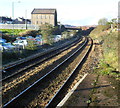
Saron chapel viewed from Treforest railway station
The large building, centre left, is Saron Welsh Calvinistic Methodist Chapel. http://www.geograph.org.uk/photo/2753581
The station http://www.geograph.org.uk/photo/2753598 is on the Merthyr Line and the Rhondda Line, 18 km NW of Cardiff Central. The next station ahead is Pontypridd, about a mile (1.6 km) away.
Image: © Jaggery
Taken: 9 Dec 2011
0.05 miles
7
The Bridge pub, Treforest
Located on the corner of Saron Street and Bridge Street. Some sources show "Bridge Inn" or "Bridge Hotel" but the name engraved in stone and the pub sign show "The Bridge."
Image: © Jaggery
Taken: 9 Dec 2011
0.05 miles
8
Saron Street, Treforest
Looking towards Bridge Street from the edge of Saron Welsh Calvinistic Methodist Chapel.http://www.geograph.org.uk/photo/2753581
Image: © Jaggery
Taken: 9 Dec 2011
0.05 miles
9
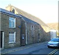
Former St. Dubritius R.C. Chapel, Treforest
Wooden boards cover the windows and doors of this apparently long derelict building on Bridge Street. Old maps name it as St. Dubritius's R.C. chapel. A 1943 map describes it as a hall. A 1960 map shows Boys Club.
Image: © Jaggery
Taken: 9 Dec 2011
0.05 miles
10
Kingsland Terrace, Treforest
Looking north from Duke Street.
Image: © Jaggery
Taken: 30 Jan 2014
0.05 miles


