IMAGES TAKEN NEAR TO
Wood Road, PONTYPRIDD, CF37 1RG
Introduction
This page details the photographs taken nearby to Wood Road, CF37 1RG by members of the Geograph project.
The Geograph project started in 2005 with the aim of publishing, organising and preserving representative images for every square kilometre of Great Britain, Ireland and the Isle of Man.

There are currently over 7.5m images from over14,400 individuals and you can help contribute to the project by visiting https://www.geograph.org.uk
Image Map
Images are licensed for reuse under creativecommons.org/licenses/by-sa/2.0
Notes
- Clicking on the map will re-center to the selected point.
- The higher the marker number, the further away the image location is from the centre of the postcode.
Image Listing (75 Images Found)
Images are licensed for reuse under creativecommons.org/licenses/by-sa/2.0
Image
Details
Distance
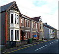
1
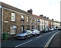
Wood Road, Pontypridd
The western end of Wood Road viewed from the eastern end of Rickards Street.
Image: © Jaggery
Taken: 12 Jan 2012
0.01 miles
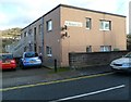
2
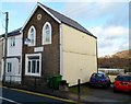
House formerly part of St Michael's School, Pontypridd
The house, on the north side of Wood Road, was formerly part of the otherwise demolished St Michael's Catholic School. There is an inscription of three lines on a tablet on the wall between the two rows of windows. The first line has been obliterated. The second and third lines are GRAMMAR SCHOOL and 1875. This cannot refer to St Michael's, which was not a grammar school and did not occupy this site until 1883. The house was for a time the residence of the school caretaker.
Image: © Jaggery
Taken: 12 Jan 2012
0.01 miles
3
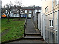
Ramp from Cliff Terrace to Wood Road, Pontypridd
Viewed from near the former Pontypridd Synagogue. http://www.geograph.org.uk/photo/3208830
Image: © Jaggery
Taken: 12 Jan 2012
0.03 miles
4
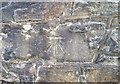
Ordnance Survey Cut Mark
This OS cut mark can be found at the junction of Wood Road & Cliff Terrace. It marks a point 85.341m above mean sea level.
Image: © Adrian Dust
Taken: 23 Jun 2018
0.03 miles
5
St Michael's Court, Pontypridd
Flats on the north side of Wood Road, occupying part of the site of the demolished St Michael's School.
Image: © Jaggery
Taken: 12 Jan 2012
0.03 miles
6
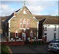
Former Pontypridd Synagogue
The former synagogue at the NW end of Cliff Terrace is now in residential use.
Image: © Jaggery
Taken: 12 Jan 2012
0.04 miles
7
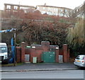
Broadway urinal, Treforest
Basic facility for males (no pedestals or wash basin) located next to Broadway Van Centre. http://www.geograph.org.uk/photo/2756692
The hilltop houses are on Cliff Terrace.
Image: © Jaggery
Taken: 9 Dec 2011
0.06 miles
8
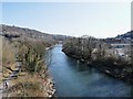
Taff view towards Treforest
The view of the taff and the footpath below from the bridge carrying the A4058.
Image: © Derek Cummings
Taken: 7 Mar 2010
0.06 miles
9
Two semis, Rickards Street, Pontypridd
These two semi-detached houses are in an area of Pontypridd
where the houses are mostly in rows of varying length.
Image: © Jaggery
Taken: 12 Jan 2012
0.06 miles
10
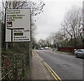
Directions sign on the approach to Pontypridd town centre
Alongside Broadway on the approach to the A4058.
Image: © Jaggery
Taken: 8 Mar 2019
0.06 miles