IMAGES TAKEN NEAR TO
Lower Alma Terrace, PONTYPRIDD, CF37 1NL
Introduction
This page details the photographs taken nearby to Lower Alma Terrace, CF37 1NL by members of the Geograph project.
The Geograph project started in 2005 with the aim of publishing, organising and preserving representative images for every square kilometre of Great Britain, Ireland and the Isle of Man.

There are currently over 7.5m images from over14,400 individuals and you can help contribute to the project by visiting https://www.geograph.org.uk
Image Map
Images are licensed for reuse under creativecommons.org/licenses/by-sa/2.0
Notes
- Clicking on the map will re-center to the selected point.
- The higher the marker number, the further away the image location is from the centre of the postcode.
Image Listing (98 Images Found)
Images are licensed for reuse under creativecommons.org/licenses/by-sa/2.0
Image
Details
Distance
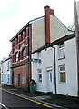
1
Laura Street, Pontypridd
Laura Street climbs away from Tower Street.
Image: © Jaggery
Taken: 12 Jan 2012
0.02 miles
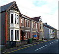
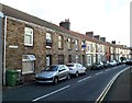
2
Mitchells Terrace, Pontypridd
Mitchells Terrace is a separately-named row of houses on the north side of Rickards Street.
Image: © Jaggery
Taken: 12 Jan 2012
0.03 miles
3
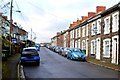
Two semis, Rickards Street, Pontypridd
These two semi-detached houses are in an area of Pontypridd
where the houses are mostly in rows of varying length.
Image: © Jaggery
Taken: 12 Jan 2012
0.03 miles
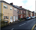
4
44 Rickards Street, Pontypridd
3 storeys high, 44 Rickards Street is conspicuously unlike neighbouring properties.
Now in residential use, it was probably once a shop or pub.
Image: © Jaggery
Taken: 12 Jan 2012
0.06 miles
5
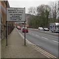
For Rhondda Valleys Use Both Lanes, Pontypridd
The sign faces westbound traffic on the A4058. The text is also in Welsh.
Image: © Jaggery
Taken: 8 Mar 2019
0.07 miles
6
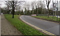
From Broadway to the A4058, Pontypridd
The A4058 ahead is on the south bank of the River Taff.
Image: © Jaggery
Taken: 8 Mar 2019
0.07 miles
7
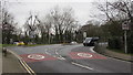
From 30 to 40 on Broadway, Pontypridd
The speed limit increases to 40mph on the approach to the A4058 junction.
Image: © Jaggery
Taken: 8 Mar 2019
0.07 miles
8
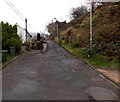
Towards the eastern end of Graig Terrace, Graig, Pontypridd
Not a through route.
Image: © Jaggery
Taken: 19 Nov 2014
0.07 miles
9
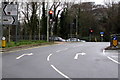
Traffic lights at the western end of Broadway, Pontypridd
At the A4058 junction.
Image: © Jaggery
Taken: 8 Mar 2019
0.07 miles
10
Wood Road, Pontypridd
The western end of Wood Road viewed from the eastern end of Rickards Street.
Image: © Jaggery
Taken: 12 Jan 2012
0.08 miles