IMAGES TAKEN NEAR TO
Maesycoed Road, PONTYPRIDD, CF37 1HZ
Introduction
This page details the photographs taken nearby to Maesycoed Road, CF37 1HZ by members of the Geograph project.
The Geograph project started in 2005 with the aim of publishing, organising and preserving representative images for every square kilometre of Great Britain, Ireland and the Isle of Man.

There are currently over 7.5m images from over14,400 individuals and you can help contribute to the project by visiting https://www.geograph.org.uk
Image Map
Images are licensed for reuse under creativecommons.org/licenses/by-sa/2.0
Notes
- Clicking on the map will re-center to the selected point.
- The higher the marker number, the further away the image location is from the centre of the postcode.
Image Listing (81 Images Found)
Images are licensed for reuse under creativecommons.org/licenses/by-sa/2.0
Image
Details
Distance
1
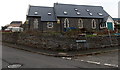
Conversion of the former St Mark?s Church, Pontypridd
Viewed across Seaton Street in November 2014. In March 2011, the Wales Online website reported the Parochial Church Council's announcement that St Mark's Church in the Church in Wales Diocese of Llandaff was to close after the church fell into financial hardship. Dwindling attendances, coupled with high rents, forced the closure. St Mark’s was built in 1892.
Image: © Jaggery
Taken: 19 Nov 2014
0.02 miles
2
Golygfa'r Eglwys in Pontypridd
Looking ESE from near this http://www.geograph.org.uk/photo/4254069 entrance to Barry Sidings Country Park. The houses on the south (right) side of Golygfa'r Eglwys are opposite the backs of houses in Seaton Street, behind railings.
Image: © Jaggery
Taken: 19 Nov 2014
0.03 miles
3
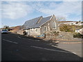
Former church, Golgafar Eglwys, Pontypridd
Image: © John Lord
Taken: 30 Oct 2017
0.04 miles
4
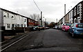
Older and newer, Seaton Street, Pontypridd
Older houses on the right. Newer houses in St Mark's Villas on the left.
Image: © Jaggery
Taken: 19 Nov 2014
0.04 miles
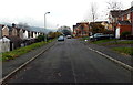
5
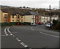
Junction of three roads in Pwllgwaun, Pontypridd
Barry Road from the left joins Maesycoed Road (lower right) and Pwllgwaun Road (ahead)
Image: © Jaggery
Taken: 19 Nov 2014
0.04 miles

7
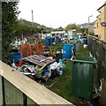
Barry Road allotments, Pontypridd
This is the SE (Pwllgwaun Road) end of a 100 metre long narrow strip of allotments
alongside Barry Road. The allotments are owned by Rhondda Cynon Taf Council.
Image: © Jaggery
Taken: 19 Nov 2014
0.05 miles
8
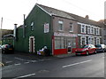
Hong Kong, Pontypridd
Chinese takeaway and fish & chip shop at 13 Pwllgwaun Road.
Image: © Jaggery
Taken: 12 Jan 2012
0.07 miles
9
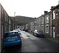
Vaughan Street, Pontypridd
Viewed from a bend in Vaughan Street, looking towards Upper Vaughan Street.
Image: © Jaggery
Taken: 12 Jan 2012
0.07 miles
