IMAGES TAKEN NEAR TO
Heol Croesty, BRIDGEND, CF35 5LR
Introduction
This page details the photographs taken nearby to Heol Croesty, CF35 5LR by members of the Geograph project.
The Geograph project started in 2005 with the aim of publishing, organising and preserving representative images for every square kilometre of Great Britain, Ireland and the Isle of Man.

There are currently over 7.5m images from over14,400 individuals and you can help contribute to the project by visiting https://www.geograph.org.uk
Image Map
Images are licensed for reuse under creativecommons.org/licenses/by-sa/2.0
Notes
- Clicking on the map will re-center to the selected point.
- The higher the marker number, the further away the image location is from the centre of the postcode.
Image Listing (43 Images Found)
Images are licensed for reuse under creativecommons.org/licenses/by-sa/2.0
Image
Details
Distance
1
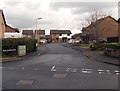
Heol Pantruthin, Pencoed
Cul-de-sac on the north side of Heol Maes-yr-Haf.
Image: © Jaggery
Taken: 9 Nov 2014
0.05 miles
2
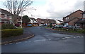
Heol Bryncwtyn, Pencoed
Cul-de-sac on the north side of Heol Maes-yr-Haf.
Image: © Jaggery
Taken: 9 Nov 2014
0.05 miles
3
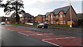
Recently-built houses, Coychurch Road, Pencoed
Viewed in November 2014. This was the location of the Maerdy Hotel http://www.geograph.org.uk/photo/2266982 which was demolished in 2013.
Image: © Jaggery
Taken: 9 Nov 2014
0.06 miles
4
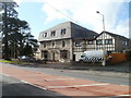
Maerdy Hotel, Pencoed
3-star hotel and conference centre, Coychurch Road.
UPDATE The hotel was demolished in 2013.
This http://www.geograph.org.uk/photo/4387774 November 2014 view shows recently-built houses on the site.
Image: © Jaggery
Taken: 12 Feb 2011
0.07 miles
5
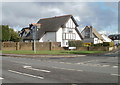
Distinctively roofed house, Heol Croesty, Pencoed
House on the corner of Heol Croesty, viewed across Coychurch Road.
Image: © Jaggery
Taken: 12 Feb 2011
0.07 miles
6
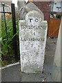
Old Milestone by Coychurch Road, Pencoed
Stone post by the UC road (was A473), in parish of Pencoed (Bridgend County Borough District), Coychurch Road, Pencoed, against wall of bungalow "Cartref".
TO
BRIDGEND
4
LANTRISSENT
7
Grade II listed by Cadw.
Reference Number: 19477 https://cadwpublic-api.azurewebsites.net/reports/listedbuilding/FullReport?lang=&id=19477
Surveyed
Milestone Society National ID: GLA_BELT04
Image: © Milestone Society
Taken: Unknown
0.07 miles
7
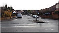
Heol Maes yr Haf, Pencoed
Viewed from Coychurch Road looking towards an area of houses on the north side of the M4 motorway.
Image: © Jaggery
Taken: 9 Nov 2014
0.10 miles
8
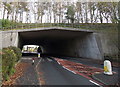
Under the M4 motorway, Pencoed
Coychurch Road passes under the bridge carrying the M4.
Image: © Jaggery
Taken: 9 Nov 2014
0.10 miles
9
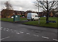
Left for Pont Newydd houses, right for Heol Ewenny houses, Pencoed
Viewed from Heol Maes-yr-Haf in an area of modern houses between Coychurch Road and the Ewenny River. The dark green cabinet is Beechwood Sewage Pumping Station, Welsh Water Asset No. 53075.
Image: © Jaggery
Taken: 9 Nov 2014
0.11 miles
10
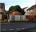
Heol Maes-yr-Haf electricity substation
Located in an area of modern houses between Coychurch Road and the Ewenny River. The identifier on the Western Power Distribution electricity substation is HEOL MAES-YR-HAF S/S 561245.
Image: © Jaggery
Taken: 9 Nov 2014
0.11 miles