1
Ordnance Survey Cut Mark
This OS cut mark can be found on the wall post of St Michael & All Angels Church. It marks a point 146.664m above mean sea level.
Image: © Adrian Dust
Taken: 9 Mar 2016
0.09 miles
2
St Michael's Church, Maesteg
Image: © John Lord
Taken: 22 Jul 2012
0.10 miles
3
St Michael's Church, Maesteg
Image: © John Lord
Taken: 22 Jul 2012
0.10 miles
4
St Michael's Church, Maesteg
Image: © John Lord
Taken: 22 Jul 2012
0.10 miles
5
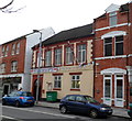
The Royal British Legion, Maesteg
Located in Commercial Street.
Founded as the British Legion in 1921, the charity was granted a Royal Charter in May 1971 to mark its fiftieth anniversary. This gave the Legion the privilege of the prefix Royal. The charity gives financial, social and emotional support to those who have served, or are currently serving, in the British Armed Forces, and their dependants.
Image: © Jaggery
Taken: 17 Nov 2011
0.11 miles
6
The Prince of Wales, Maesteg
The pub at 119 Commercial Street is flanked on the right by a fish & chip shop, A Chip Off The Old Block and on the left by the Momtaj licensed Indian restaurant, with a takeaway service available.
Image: © Jaggery
Taken: 17 Nov 2011
0.11 miles
7
King Alfred pub sign, Maesteg
The sign hanging from a frame on the wall of this pub http://www.geograph.org.uk/photo/2955830 is based
on the statue of King Alfred in Wantage Market Square. http://www.geograph.org.uk/photo/1395703
Image: © Jaggery
Taken: 17 Nov 2011
0.14 miles
8
King Alfred, Maesteg
Pub on the corner of Talbot Street and Commercial Street.
Image: © Jaggery
Taken: 17 Nov 2011
0.14 miles
9
Hartshorn House, Maesteg
On the corner of Neath Road and Llynfi Road, facing the corner of Talbot Street and Commercial Street. Various inscriptions on the corner, from top to bottom, are:
1910
CO-OPERATIVE
HARTSHORN HOUSE
BOWRINGTON ARCADE
ARCADE CAFE.
The building is now multi-use, occupied by flats and several businesses.
Image: © Jaggery
Taken: 17 Nov 2011
0.14 miles
10
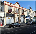
Former Sawyers Arms pub, Maesteg
An auctioneer's board is on the wall of the former Sawyers Arms pub, at the NW end of Commercial Street. The ground floor door and windows are protected by sheet metal. Though the pub name has been removed, silhouettes of the name remain above the window arches.
Image: © Jaggery
Taken: 17 Nov 2011
0.14 miles


