
IMAGES TAKEN NEAR TO
Commercial Street, MAESTEG, CF34 9DW
Introduction
This page details the photographs taken nearby to Commercial Street, CF34 9DW by members of the Geograph project.
The Geograph project started in 2005 with the aim of publishing, organising and preserving representative images for every square kilometre of Great Britain, Ireland and the Isle of Man.

There are currently over 7.5m images from over14,400 individuals and you can help contribute to the project by visiting https://www.geograph.org.uk
Image Map
Images are licensed for reuse under creativecommons.org/licenses/by-sa/2.0
Notes
- Clicking on the map will re-center to the selected point.
- The higher the marker number, the further away the image location is from the centre of the postcode.
Image Listing (185 Images Found)
Images are licensed for reuse under creativecommons.org/licenses/by-sa/2.0
Image
Details
Distance
1
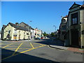
Commercial St, Maesteg
Viewed from its junction with Neath Rd.
Image: © John Lord
Taken: 22 Jul 2012
0.02 miles
2
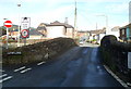
Small stone bridge over the River Llynfi, Church Street, Maesteg
At the Llynfi Lane junction, Church Street crosses the River Llynfi over a bridge with a 5 tonnes weight limit.
Image: © Jaggery
Taken: 17 Nov 2011
0.03 miles
3
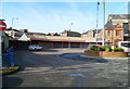
Southern side of Maesteg Bus Station
Viewed across Church Street. First Cymru operate most of the buses in the Maesteg area.
Image: © Jaggery
Taken: 17 Nov 2011
0.03 miles
4
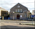
Central Church, Maesteg
Located on the eastern side of Church Street, facing the bus station, market and town hall. http://www.geograph.org.uk/photo/2699690
Built in 1859 as Bethel English Baptist Chapel.
Image: © Jaggery
Taken: 17 Nov 2011
0.03 miles
5
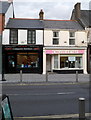
Create a Cake, Maesteg
Located at 22 Commercial Street, the shop's business is made-to-order
individually-designed cakes for weddings and other special occasions.
Next door is ITCS Computer Services.
Image: © Jaggery
Taken: 17 Nov 2011
0.03 miles
6
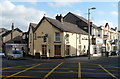
King Alfred, Maesteg
Pub on the corner of Talbot Street and Commercial Street.
Image: © Jaggery
Taken: 17 Nov 2011
0.04 miles
7
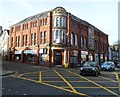
Hartshorn House, Maesteg
On the corner of Neath Road and Llynfi Road, facing the corner of Talbot Street and Commercial Street. Various inscriptions on the corner, from top to bottom, are:
1910
CO-OPERATIVE
HARTSHORN HOUSE
BOWRINGTON ARCADE
ARCADE CAFE.
The building is now multi-use, occupied by flats and several businesses.
Image: © Jaggery
Taken: 17 Nov 2011
0.04 miles
8
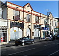
Former Sawyers Arms pub, Maesteg
An auctioneer's board is on the wall of the former Sawyers Arms pub, at the NW end of Commercial Street. The ground floor door and windows are protected by sheet metal. Though the pub name has been removed, silhouettes of the name remain above the window arches.
Image: © Jaggery
Taken: 17 Nov 2011
0.04 miles
9
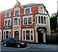
Star Hotel, Maesteg
Pub at 144 Commercial Street. The date stone above the door and window shows the year 1901.
Image: © Jaggery
Taken: 17 Nov 2011
0.04 miles
10

King Alfred pub sign, Maesteg
The sign hanging from a frame on the wall of this pub http://www.geograph.org.uk/photo/2955830 is based
on the statue of King Alfred in Wantage Market Square. http://www.geograph.org.uk/photo/1395703
Image: © Jaggery
Taken: 17 Nov 2011
0.04 miles