1
Maesteg (south)
looking North at housing at the South end of Maesteg high above the valley.
Image: © Chris Shaw
Taken: Unknown
0.08 miles
2
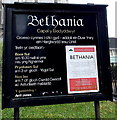
Welsh only name and information board outside Bethania Chapel, Maesteg
Apart from the bilingual notice in the lower right corner, all the text in view is in Welsh only.
The board is outside this http://www.geograph.org.uk/photo/4225266 chapel.
Image: © Jaggery
Taken: 30 Oct 2014
0.22 miles
3
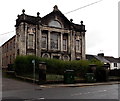
Bethania Chapel, Maesteg
Viewed across Bethania Street from the corner of Ewenny Road. A Welsh Religious Buildings Trust notice on the nameboard states that Bethania is a Grade II* listed building, designed by local architect William Beddoe Rees and an important example of Welsh Nonconformist Heritage. Other information on the chapel board http://www.geograph.org.uk/photo/4225278 is in Welsh only.
Image: © Jaggery
Taken: 30 Oct 2014
0.22 miles
4
The Royal Oak, Maesteg
Bethania Street pub, opposite the Ewenny Road junction.
Image: © Jaggery
Taken: 30 Oct 2014
0.22 miles
5
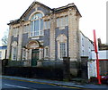
Former Bethlehem Welsh chapel (Presbyterian) in Maesteg
Located in Bethania Street, opposite Bethania Chapel. http://www.geograph.org.uk/photo/4225266 Built in 1905, Bethlehem was noted as
still in use in 1997. In late October 2014, the nameboard has gone and the lower windows are protected by sheeting.
Image: © Jaggery
Taken: 30 Oct 2014
0.23 miles
6
Black & white house and a former chapel in Maesteg
Viewed across Bethania Street. The house is on the corner of Ewenny Road,
next door to the former Bethlehem Welsh chapel. http://www.geograph.org.uk/photo/4270041
Image: © Jaggery
Taken: 30 Oct 2014
0.23 miles
7
Ordnance Survey Rivet
This OS rivet can be found on the step at the junction of Ewenny Road & Bethania Road. Originally the step leading to the PC. It marks a point 121.649m above mean sea level.
Image: © Adrian Dust
Taken: 11 Nov 2020
0.24 miles
8
The Red Cow, corner of Alma Rd and Bryn Celyn, Maesteg
Image: © John Lord
Taken: 10 Oct 2008
0.24 miles
9
Midnight Moon in Maesteg
Midnight Moon Chop Suey House is on the corner of Bethania Street
and Ewenny Road, opposite The Royal Oak pub. http://www.geograph.org.uk/photo/4225136
Image: © Jaggery
Taken: 30 Oct 2014
0.24 miles
10
Former Tabor church, Maesteg
Viewed across Commercial Street. This was formerly Tabor Calvinistic Methodist Church, built in 1907. The facade has been retained, but the rest of the building has been converted to flats. Some windows of the flats can be seen between the facade and the red sign.
Image: © Jaggery
Taken: 17 Nov 2011
0.24 miles


