1
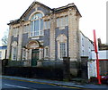
Former Tabor church, Maesteg
Viewed across Commercial Street. This was formerly Tabor Calvinistic Methodist Church, built in 1907. The facade has been retained, but the rest of the building has been converted to flats. Some windows of the flats can be seen between the facade and the red sign.
Image: © Jaggery
Taken: 17 Nov 2011
0.00 miles
2
Tabor Chapel, Maesteg.
Former chapel now converted to residential use.
Image: © David Lewis
Taken: Unknown
0.04 miles
3
River Llynfi flows away from Meadow Street footbridge, Maesteg
Viewed from the footbridge http://www.geograph.org.uk/photo/4229075 connecting the southern end of Meadow Street with Commercial Street.
The Llynfi is a tributary of the River Ogmore, into which it flows at Aberkenfig.
Image: © Jaggery
Taken: 17 Nov 2011
0.06 miles
4
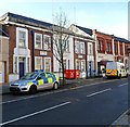
Maesteg Police Station
A police car and police van are parked outside the Commercial Street police station, part of the South Wales Police force. The inscription in stone on the building is COUNTY POLICE STATION 1938.
Image: © Jaggery
Taken: 17 Nov 2011
0.06 miles
5
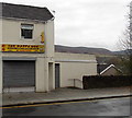
The Happy Wok, Maesteg
Chinese & Cantonese cuisine takeaway in Commercial Street.
Image: © Jaggery
Taken: 30 Oct 2014
0.06 miles
6
River footbridge to Commercial Street, Maesteg
Viewed from the southern end of Meadow Street. The footbridge spans the River Llynfi.
Image: © Jaggery
Taken: 30 Oct 2014
0.07 miles
7
Yellow litter bin on a river footbridge in Maesteg
The old-style bin is on the River Llynfi footbridge from Commercial Street to Meadow Street (ahead).
Image: © Jaggery
Taken: 30 Oct 2014
0.07 miles
8
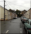
Meadow Street, Maesteg
Looking south from the corner of Alfred Street.
100 metres ahead, Meadow Street ends at the north bank of the River Llynfi.
Image: © Jaggery
Taken: 30 Oct 2014
0.07 miles
9
Short row of houses at the southern end of Meadow Street, Maesteg
Between the corner of River Street http://www.geograph.org.uk/photo/4228966 and the River Llynfi.
Image: © Jaggery
Taken: 30 Oct 2014
0.08 miles
10
River Llynfi flows towards Meadow Street footbridge, Maesteg
Viewed from the footbridge http://www.geograph.org.uk/photo/4229075 from the southern end of Meadow Street to Commercial Street.
Image: © Jaggery
Taken: 17 Nov 2011
0.09 miles


