IMAGES TAKEN NEAR TO
Ffordd Ddu, BRIDGEND, CF33 6JG
Introduction
This page details the photographs taken nearby to Ffordd Ddu, CF33 6JG by members of the Geograph project.
The Geograph project started in 2005 with the aim of publishing, organising and preserving representative images for every square kilometre of Great Britain, Ireland and the Isle of Man.

There are currently over 7.5m images from over14,400 individuals and you can help contribute to the project by visiting https://www.geograph.org.uk
Image Map
Images are licensed for reuse under creativecommons.org/licenses/by-sa/2.0
Notes
- Clicking on the map will re-center to the selected point.
- The higher the marker number, the further away the image location is from the centre of the postcode.
Image Listing (62 Images Found)
Images are licensed for reuse under creativecommons.org/licenses/by-sa/2.0
Image
Details
Distance
1
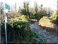
Track on Wales Coast Path diversion, Pyle
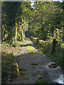
At the time of submission of this photograph, the track seen is one of a series of paths to be used by those walking the Wales Coast Path until the opening of a footbridge across the Afon Cynffig near its mouth and establishment of a path at Margam Moors enable a route on, or close, to the coast to be followed between Kenfig Burrows and Margam. The current, temporary section of the Coast Path between these places – identified as a ‘diversion’ on some maps - takes the walker a considerable distance inland and is approximately six and a half miles long. As well as taking in the track seen here, it passes along the adjoining track seen in Image
Image: © eswales
Taken: 6 Oct 2012
0.02 miles
2
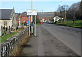
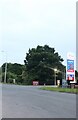
Pyle Road, Pyle
A view north along Pyle Road (the A48), 4 miles from Margam and 6 from Port Talbot.
The Church of St James http://www.geograph.org.uk/photo/3244151 is on the left.
Image: © Jaggery
Taken: 29 Nov 2012
0.03 miles
3
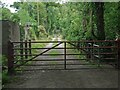
Track, Pyle on a Wales Coast Path alternative route
The track seen lies on a stretch of the Wales Coast Path which runs between the south of Kenfig Burrows and Margam via Pyle and is an alternative to walking between the two on the closer-to-the-coast route through the north of Kenfig Burrows and Margam Moors. The idea of the alternative route – which is approximately 11 kilometres long and, like the ‘preferred’ route, marked Wales Coast Path on Ordnance Survey maps - appears to be that it is to be used when weather conditions prevent or make difficult passage along the route via Margam Moors, which is prone to flooding.
The gate in the image prevents vehicles travelling further west along the track. Those on foot can continue walking along it by using a stile situated just out of shot to the right of the gate.
Image: © eswales
Taken: 15 Jun 2022
0.04 miles
4
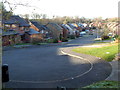
Ffordd Ddu houses, Pyle
Viewed from the edge of Pyle Road (A48) near Ye Olde Wine House. http://www.geograph.org.uk/photo/3244162
Image: © Jaggery
Taken: 29 Nov 2012
0.04 miles
6
Path past the northern side of St James Church, Pyle
Viewed from the edge of Pyle Road (the A48).
Image: © Jaggery
Taken: 29 Nov 2012
0.04 miles
8
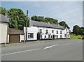
Pyle, Ye Olde Wine House
Public house and restaurant on Pyle Road; back bar, serving two rooms: left, eating, right, drinking. Exposed stonework, open fires, wooden beams; no cask ales.
Image: © Mike Faherty
Taken: 14 Jul 2016
0.04 miles
9
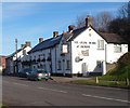
Ye Olde Wine House, Pyle
Viewed across Pyle Road (the A48). Also known as The Tap, this former coaching inn dating from the late 17th century has had other names at various times, including The Inn at Pyle, The White Hart and The Old House.
Image: © Jaggery
Taken: 29 Nov 2012
0.05 miles
10
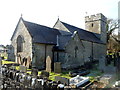
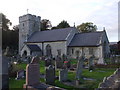
North side of St James Church, Pyle
Viewed from Pyle Road (the A48). This is the Church of St James, Pyle, in the Church in Wales
parish of Pyle and Kenfig. http://www.geograph.org.uk/photo/3244151 to a view of the south side.
Image: © Jaggery
Taken: 29 Nov 2012
0.05 miles