IMAGES TAKEN NEAR TO
Tythegston, BRIDGEND, CF32 0NE
Introduction
This page details the photographs taken nearby to CF32 0NE by members of the Geograph project.
The Geograph project started in 2005 with the aim of publishing, organising and preserving representative images for every square kilometre of Great Britain, Ireland and the Isle of Man.

There are currently over 7.5m images from over14,400 individuals and you can help contribute to the project by visiting https://www.geograph.org.uk
Image Map
Images are licensed for reuse under creativecommons.org/licenses/by-sa/2.0
Notes
- Clicking on the map will re-center to the selected point.
- The higher the marker number, the further away the image location is from the centre of the postcode.
Image Listing (45 Images Found)
Images are licensed for reuse under creativecommons.org/licenses/by-sa/2.0
Image
Details
Distance
1
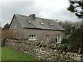
Cottage at Tythegston
Cottage on the Tythegston Estate.
Image: © Alan Hughes
Taken: 27 Jan 2016
0.01 miles
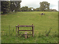
2
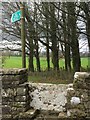
Stile at Tythegston
Stile to footpath on Tythegston estate.
Image: © Alan Hughes
Taken: 27 Jan 2016
0.03 miles
3
Minor road arriving at Tythegston
The green sign lies at the start of a public footpath which runs northwards to the A 48 via the Long Belt of ancient woodland and the ruin of Ty-erfin.
Image: © eswales
Taken: 23 Sep 2016
0.04 miles
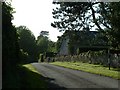
4
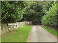
Road through Tythegston Estate
Road past the tradesmen's entrance to Tythegston Court.
Image: © Alan Hughes
Taken: 27 Jan 2016
0.05 miles
5
View towards the southern edge of Home Wood, Tythegston
The image shows part of the southern edge of the wood of broadleaf trees situated several hundred metres north west of Tythegston hamlet. Much of the wood is comprised of ancient woodland, with areas of both Ancient Semi Natural Woodland and Restored Ancient Woodland according to the Welsh Ancient Woodland Inventory of 2021 - https://naturalresources.wales/evidence-and-data/research-and-reports/ancient-woodland-inventory/?lang=en and http://lle.gov.wales/catalogue/item/AncientWoodlandInventory2021/?lang=en.
Image: © eswales
Taken: 12 Jan 2022
0.05 miles
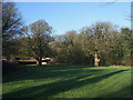
6
A view across a valley at Tythegston
This little valley is crossed by the public footpath which runs northwards from the edge of Tythegston to the A 48 via the ruins of Ty-erfin. The footpath starts at the illuminated gap in the trees/vegetation seen close to the right hand edge of the image.
Image: © eswales
Taken: 23 Sep 2016
0.06 miles
7
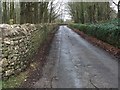
Lane and Cottage near Court
On the lane at the North of Tythegston.
Image: © Chris Shaw
Taken: Unknown
0.07 miles
8
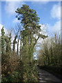
Tall conifer by lane to the north west of Tythegston
A Scots Pine towers over a very narrow lane which a sign to the north west of here declares to be unsuitable for motor vehicles.
Image: © eswales
Taken: 8 Apr 2009
0.08 miles
9
Stile on public footpath, Tythegston
The stile lies on a public footpath which runs northwards to the A48 from a spot just to the north west of Tythegston. A well is seen on the hillside beyond.
Image: © eswales
Taken: 23 Sep 2016
0.09 miles
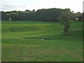
10
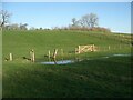
Minor flooding in a small valley by Tythegston
The picture was taken following a fairly wet spell which had begun just before Christmas 2021. There was some standing water – although not as much as seen here - on the public footpath (to Ty-erfin and the A48) on which the picture was taken, especially just to the other side of the fence seen in the foreground.
Image: © eswales
Taken: 12 Jan 2022
0.09 miles