IMAGES TAKEN NEAR TO
Laleston, BRIDGEND, CF32 0HH
Introduction
This page details the photographs taken nearby to CF32 0HH by members of the Geograph project.
The Geograph project started in 2005 with the aim of publishing, organising and preserving representative images for every square kilometre of Great Britain, Ireland and the Isle of Man.

There are currently over 7.5m images from over14,400 individuals and you can help contribute to the project by visiting https://www.geograph.org.uk
Image Map
Images are licensed for reuse under creativecommons.org/licenses/by-sa/2.0
Notes
- Clicking on the map will re-center to the selected point.
- The higher the marker number, the further away the image location is from the centre of the postcode.
Image Listing (24 Images Found)
Images are licensed for reuse under creativecommons.org/licenses/by-sa/2.0
Image
Details
Distance
1

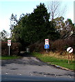
Laleston Stones Trail Junction with A473
This is a section of the Ffordd-y-Gyfrauth which was a medieval trackway.
Image: © Steve Barnes
Taken: 5 Apr 2020
0.06 miles
2
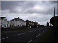
Weight restriction on a minor road in Laleston
Viewed across the A473 near the eastern edge of the village. Signs show a 3.5 tonnes weight limit (except for access) and Unsuitable for HGVs (heavy goods vehicles).
Image: © Jaggery
Taken: 24 Dec 2014
0.06 miles
3

Not much of a bus shelter in Laleston
Viewed across the A473 at the eastern edge of the village in December 2014. It was unclear
to this first-time visitor to the area whether the shelter is partly built or partly demolished.
Image: © Jaggery
Taken: 24 Dec 2014
0.07 miles
4

King George V postbox, High Street, Laleston
On the left here. http://www.geograph.org.uk/photo/4290100 MAW is short for Dydd Mawrth, Welsh for Tuesday.
Image: © Jaggery
Taken: 24 Dec 2014
0.08 miles
5
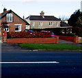
High Street postbox in Laleston
The red box on the left is in a house perimeter wall gate pier on the north side of High Street.
The village boundary sign http://www.geograph.org.uk/photo/4290094 is nearby.
Image: © Jaggery
Taken: 24 Dec 2014
0.08 miles
6
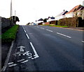
High Street cycle lane, Laleston
For cyclists heading west, into Laleston.
Image: © Jaggery
Taken: 24 Dec 2014
0.08 miles
7
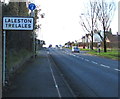
Eastern boundary of Laleston
The A473 from Bridgend reaches the eastern boundary of Laleston,
(Trelales in Welsh), a village in Bridgend County Borough.
Image: © Jaggery
Taken: 24 Dec 2014
0.09 miles
9
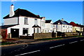
White houses in Laleston
On the north side of the A473 High Street near the eastern edge of the village.
Image: © Jaggery
Taken: 24 Dec 2014
0.10 miles
10
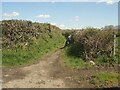
The start of a route with public access just east of Laleston
An Ordnance Survey map marked ‘other route with public access’ seen at its southern end, a junction with a lane (Ffordd y Gyfraith). No signage for this route is to be seen at the junction. The route is narrow for a good part of its length, with the appearance of a (hard-surfaced) footpath, but broadens towards its northern end, where it looks more like a country track. A local website (laleston.com @ https://www.laleston.com/laleston-stones-trail ) describes the whole route as an ‘ancient cart track’. It is approximately 500 metres long and runs to a spot on Llangewydd Road a few hundred metres west of Bryntirion in Bridgend.
Image: © eswales
Taken: 25 Apr 2023
0.11 miles