IMAGES TAKEN NEAR TO
Minster Road, CARDIFF, CF23 5SE
Introduction
This page details the photographs taken nearby to Minster Road, CF23 5SE by members of the Geograph project.
The Geograph project started in 2005 with the aim of publishing, organising and preserving representative images for every square kilometre of Great Britain, Ireland and the Isle of Man.

There are currently over 7.5m images from over14,400 individuals and you can help contribute to the project by visiting https://www.geograph.org.uk
Image Map
Images are licensed for reuse under creativecommons.org/licenses/by-sa/2.0
Notes
- Clicking on the map will re-center to the selected point.
- The higher the marker number, the further away the image location is from the centre of the postcode.
Image Listing (79 Images Found)
Images are licensed for reuse under creativecommons.org/licenses/by-sa/2.0
Image
Details
Distance
1
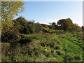
Near Roath Brook
Looking from beside Roath Brook towards Newport Road. The embankment that carried the Taff Vale Railway's Roath Branch is on the left.
Image: © Gareth James
Taken: 24 Oct 2009
0.06 miles
2
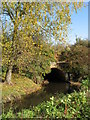
Roath Brook Bridge
Remains of the bridge that carried the Roath Branch of the Taff Vale Railway over Roath Brook.
Image: © Gareth James
Taken: 24 Oct 2009
0.08 miles
3
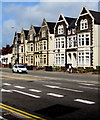
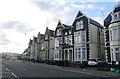
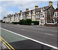
Six Newport Road semis, Cardiff
Semi-detached houses on the north side of the A4161 Newport Road.
The houses on the left are opposite the Broadway and Beresford Road junctions.
Image: © Jaggery
Taken: 16 Jun 2017
0.13 miles
4
St Margaret's from the south
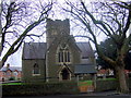
From Wikipedia "The Church of St Margaret of Antioch, built in 1870 on the site of an earlier Norman chapel. The new Gothic revival church, designed by Llandaff architect John Prichard on a Greek Cross plan, was financed totally by the third Marquess of Bute, in spite of his conversion to Catholicism in 1868. Inside is an opulent mausoleum housing tombs of nine members of the Bute family, including the First Marquess and his wives. The tower of St Margaret's was finally completed in 1926."
Image: © Natasha Ceridwen de Chroustchoff
Taken: 29 Nov 2007
0.13 miles
5
St Margaret's church, Roath
The original, mediaeval, church on this spot was demolished in the 1860's and rebuilt by the Marquess of Bute in order to incorporate a family mausoleum modelled on that of the Russian Czar - such was the power and arrogance of the Victorian industrial magnates.
All trace of the old church was removed, including the graveyard with its cross and the graves of local people. An image of it can be seen here http://www.cardiffians.co.uk/penylan_roath/index.html
Image: © Natasha Ceridwen de Chroustchoff
Taken: 29 Nov 2007
0.13 miles
7
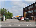
Halfords Autocentre, Newport Road, Cardiff
Set back from the north side of Newport Road.
Image: © Jaggery
Taken: 16 Jun 2017
0.14 miles
9
Long row of houses, Newport Road, Cardiff
Extending for 90 metres along the north side of the A4161 Newport Road.
Image: © Jaggery
Taken: 16 Jun 2017
0.14 miles
10
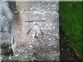
Ordnance Survey Cut Mark
This OS cut mark can be found on the north face of St Margaret's Church. It marks a point 10.296m above mean sea level.
Image: © Adrian Dust
Taken: 12 Oct 2017
0.15 miles