IMAGES TAKEN NEAR TO
Westville Road, CARDIFF, CF23 5DF
Introduction
This page details the photographs taken nearby to Westville Road, CF23 5DF by members of the Geograph project.
The Geograph project started in 2005 with the aim of publishing, organising and preserving representative images for every square kilometre of Great Britain, Ireland and the Isle of Man.

There are currently over 7.5m images from over14,400 individuals and you can help contribute to the project by visiting https://www.geograph.org.uk
Image Map
Images are licensed for reuse under creativecommons.org/licenses/by-sa/2.0
Notes
- Clicking on the map will re-center to the selected point.
- The higher the marker number, the further away the image location is from the centre of the postcode.
Image Listing (61 Images Found)
Images are licensed for reuse under creativecommons.org/licenses/by-sa/2.0
Image
Details
Distance
1
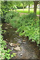
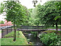
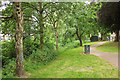
Roath Brook
Looking upstream from the footbridge shown in Image, with Roath Mill Gardens, a pleasant little listed park http://orapweb.rcahms.gov.uk/coflein//C/CPG217.pdf , extending across to Westville Road in the background. "The Roath Brook {runs} in a stone-revetted channel through the middle. This channel is in fact the former mill leat: the original brook was filled in and the water diverted into the leat."
Image: © Derek Harper
Taken: 16 Jun 2018
0.04 miles
4
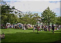
Roath Mill Gardens
With Roath Brook to the left - see Image "The park is laid out to grass and informally planted trees, the most prominent of which are oak, beech, cedar and plane. Other trees include willow, maple, cherry and hawthorn. Gravel paths run around the perimeter and across the middle" http://orapweb.rcahms.gov.uk/coflein//C/CPG217.pdf . The paths are now tarmacked.
Image: © Derek Harper
Taken: 16 Jun 2018
0.06 miles
5
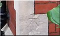
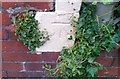
Ordnance Survey Cut Mark
This OS cut mark can be found on the NW face of No46 Sandringham Road. It marks a point 9.745m above mean sea level.
Image: © Adrian Dust
Taken: 12 Oct 2017
0.07 miles
6
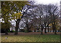
Roath Mill Gardens
The trees in this landscaped Edwardian park have reached maturity and even in late November have an attractive aspect. Not surprisingly, this is an attractive residential area too.
Image: © Natasha Ceridwen de Chroustchoff
Taken: 29 Nov 2007
0.07 miles
7
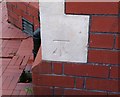
Ordnance Survey Cut Mark
This OS cut mark can be found on No115 Kimberley Road. It marks a point 15.652m above mean sea level.
Image: © Adrian Dust
Taken: 19 Nov 2017
0.07 miles
8
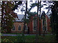
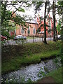
Church of St Edward King and Confessor, Roath
Blenheim Road. Seen here from across the stream in the Roath Mill Gardens.
Image: © Natasha Ceridwen de Chroustchoff
Taken: 29 Nov 2007
0.07 miles
9
Ordnance Survey Cut Mark
This OS cut mark can be found on the NE face of No16 Agincourt Road. It marks a point 10.019m above mean sea level.
Image: © Adrian Dust
Taken: 12 Oct 2017
0.08 miles