1
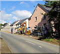
Cardiff Road construction site, Creigiau
Houses are being built on a former greenfield site at the southern edge of the village.
Viewed in mid September 2017.
Image: © Jaggery
Taken: 19 Sep 2017
0.01 miles
2
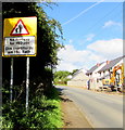
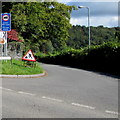
Warning sign - No footway for 150 yds, Cardiff Road, Creigiau
The text is in English and Welsh on the sign at the southern edge of the village,
a few metres beyond this http://www.geograph.org.uk/photo/5542323 Welcome/Croeso sign.
Image: © Jaggery
Taken: 19 Sep 2017
0.03 miles
3
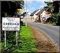
Welcome to/ Croeso i/ Creigiau
The English/Welsh sign at the southern boundary of Creigiau faces
Cardiff Road 125 metres NW of the A4119 Llantrisant Road junction.
Image: © Jaggery
Taken: 19 Sep 2017
0.04 miles
4
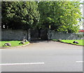
Entrance to Robin Hill House, Creigiau
From Cardiff Road at the southern edge of Creigiau.
Image: © Jaggery
Taken: 19 Sep 2017
0.06 miles
5
Cardiff Road
Image: © Colin Pyle
Taken: 9 Sep 2011
0.06 miles
6
Start of the 30 zone on Cardiff Road near Creigiau
On the approach to the southern edge of Creigiau, the National Speed Limit on Cardiff Road drops to 30mph.
Image: © Jaggery
Taken: 19 Sep 2017
0.06 miles
7
Weight restriction sign, Heol Pant y Gored near Creigiau
Facing Cardiff Road, the sign shows that there is a 7.5 tonnes vehicle weight limit on Heol Pant y Gored 750 yards ahead. The text is also in Welsh. A temporary roadworks sign is in place in mid September 2017.
Image: © Jaggery
Taken: 19 Sep 2017
0.07 miles
8
Heol Pant y Gored direction signs near Creigiau
The sign at the Cardiff Road junction pointing right along Heol Pant y Gored http://www.geograph.org.uk/photo/5542353 shows
1½ (miles) to Pentyrch, 3½ to Efailisaf. The brown sign points towards Canada Lake Lodge.
Image: © Jaggery
Taken: 19 Sep 2017
0.07 miles
9
Heol Pant y Gored near Creigiau
The road named Heol Pant y Gored heads northeast away from Cardiff Road near Creigiau.
Pointing this way, a nearby sign http://www.geograph.org.uk/photo/5542365 shows 1½ (miles) to Pentyrch, 3½ to Efailisaf.
Image: © Jaggery
Taken: 19 Sep 2017
0.07 miles
10
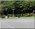
Roadside weather station, Cardiff Road near Creigiau
Opposite the Heol y Gored junction on the southern approach to Creigiau.
The meteorological instruments on top of the metal pole measure air temperature, wind speed etc. Also in view are a Virgin Media telecoms cabinet on the left, a BT telecoms cabinet centre right and a yellow grit/salt box.
Image: © Jaggery
Taken: 19 Sep 2017
0.08 miles


