IMAGES TAKEN NEAR TO
Brummell Drive, CARDIFF, CF15 9NX
Introduction
This page details the photographs taken nearby to Brummell Drive, CF15 9NX by members of the Geograph project.
The Geograph project started in 2005 with the aim of publishing, organising and preserving representative images for every square kilometre of Great Britain, Ireland and the Isle of Man.

There are currently over 7.5m images from over14,400 individuals and you can help contribute to the project by visiting https://www.geograph.org.uk
Image Map
Images are licensed for reuse under creativecommons.org/licenses/by-sa/2.0
Notes
- Clicking on the map will re-center to the selected point.
- The higher the marker number, the further away the image location is from the centre of the postcode.
Image Listing (32 Images Found)
Images are licensed for reuse under creativecommons.org/licenses/by-sa/2.0
Image
Details
Distance
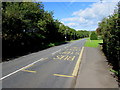
1
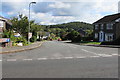
Brummell Drive, Creigiau
Cul-de-sac viewed across Cardiff Road.
Image: © Jaggery
Taken: 19 Sep 2017
0.02 miles
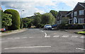
2
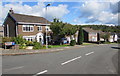
Brummell Drive houses, Creigiau
Houses on the north side of Brummell Drive, viewed from the corner of Cardiff Road.
Image: © Jaggery
Taken: 19 Sep 2017
0.03 miles
3
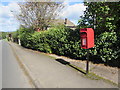
Queen Elizabeth II postbox, Cardiff Road, Creigiau
Alongside Cardiff Road a few metres from the corner of Brummell Drive. http://www.geograph.org.uk/photo/5542287
The maker's name embossed on the lower right corner of the box is MACHAN SCOTLAND.
The Daily Record newspaper reported in October 2015 that Machan Engineering of Falkirk,
the only foundry in the UK to make traditional postboxes, closed down after a slump in orders.
Image: © Jaggery
Taken: 19 Sep 2017
0.05 miles
4
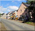
Cardiff Road construction site, Creigiau
Houses are being built on a former greenfield site at the southern edge of the village.
Viewed in mid September 2017.
Image: © Jaggery
Taken: 19 Sep 2017
0.09 miles
5
Cardiff Road bus stop, Creigiau
This stop near the corner of Queen Charlotte Drive is for buses to Cardiff and to Maerdy in the Rhondda.
Image: © Jaggery
Taken: 19 Sep 2017
0.09 miles
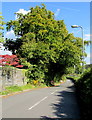
6
Queen Charlotte Drive, Creigiau
Cul-de-sac on the east side of Cardiff Road.
Image: © Jaggery
Taken: 19 Sep 2017
0.10 miles
7
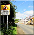
Warning sign - No footway for 150 yds, Cardiff Road, Creigiau
The text is in English and Welsh on the sign at the southern edge of the village,
a few metres beyond this http://www.geograph.org.uk/photo/5542323 Welcome/Croeso sign.
Image: © Jaggery
Taken: 19 Sep 2017
0.10 miles
8
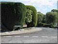
Corner of Cardiff Road and Queen Charlotte Drive, Creigiau
The larger sign shows that Queen Charlotte Drive http://www.geograph.org.uk/photo/5543561 is a cul-de-sac.
Image: © Jaggery
Taken: 19 Sep 2017
0.12 miles
9
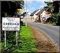
Welcome to/ Croeso i/ Creigiau
The English/Welsh sign at the southern boundary of Creigiau faces
Cardiff Road 125 metres NW of the A4119 Llantrisant Road junction.
Image: © Jaggery
Taken: 19 Sep 2017
0.12 miles
10
Heol Pant y Gored near Creigiau
The road named Heol Pant y Gored heads northeast away from Cardiff Road near Creigiau.
Pointing this way, a nearby sign http://www.geograph.org.uk/photo/5542365 shows 1½ (miles) to Pentyrch, 3½ to Efailisaf.
Image: © Jaggery
Taken: 19 Sep 2017
0.13 miles