IMAGES TAKEN NEAR TO
Fairfield Industrial Estate, CARDIFF, CF15 8LA
Introduction
This page details the photographs taken nearby to Fairfield Industrial Estate, CF15 8LA by members of the Geograph project.
The Geograph project started in 2005 with the aim of publishing, organising and preserving representative images for every square kilometre of Great Britain, Ireland and the Isle of Man.

There are currently over 7.5m images from over14,400 individuals and you can help contribute to the project by visiting https://www.geograph.org.uk
Image Map
Images are licensed for reuse under creativecommons.org/licenses/by-sa/2.0
Notes
- Clicking on the map will re-center to the selected point.
- The higher the marker number, the further away the image location is from the centre of the postcode.
Image Listing (146 Images Found)
Images are licensed for reuse under creativecommons.org/licenses/by-sa/2.0
Image
Details
Distance
1
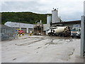
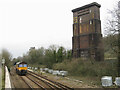
Readymixed concrete plant at Taffs Well
The readymix plant now operates as Tarmac, but in recent years has traded as Lafarge Tarmac and as Minimix Wales, which was its original name before being bought by Lafarge UK. Updates to the site signage and vehicle livery are in hand at the time of writing.
Image: © Richard Law
Taken: 7 Aug 2015
0.03 miles
2
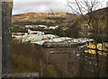
Taffs Well Viaduct Remains
The photo shows the two remaining piers of the viaduct that carried the Barry Railway across the Garth Gap. The brickwork on the left of the photo is part of the viaduct.
Image: © Guy Butler-Madden
Taken: 10 Mar 2007
0.06 miles
3
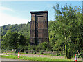
The remaining pier of Walnut Tree Viaduct
Image: © Gareth James
Taken: 3 Sep 2023
0.07 miles
4
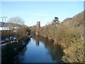
River Taff upstream from the B4262 bridge
Viewed from the newer http://www.geograph.org.uk/photo/1276106 of two adjacent road bridges across the Taff. In the distance is a bridge pier, http://www.geograph.org.uk/photo/514531 once part of a railway viaduct.
Image: © Jaggery
Taken: 29 Nov 2010
0.08 miles
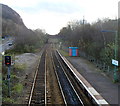
5
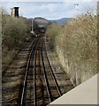
Railway towards Taffs Well station
Looking NNW along the combined Merthyr Line and Rhondda Line towards Taffs Well station.
On the left is the top of the remains http://www.geograph.org.uk/photo/514531 of a former Barry Railway viaduct.
Image: © Jaggery
Taken: 3 Mar 2015
0.08 miles
6
Class 66 locomotive and pier of Walnut Tree Viaduct
Colas Rail class 66 locomotive No. 66849 sits beneath the remaining pier of Walnut Tree Viaduct during an engineers' possession for track work around Taffs Well station.
Image: © Gareth James
Taken: 1 Mar 2022
0.08 miles
7
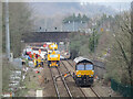
Track replacement at Taffs Well
Colas Rail class 66 locomotive No. 66849 sits near Taffs Well during an engineers' possession for track work around the station.
Image: © Gareth James
Taken: 1 Mar 2022
0.08 miles
8
A view SE from Taffs Well railway station
Looking towards the bridge carrying Cardiff Road (A4054). The next station in this direction is Radyr, a suburb of Cardiff.
Image: © Jaggery
Taken: 9 Dec 2011
0.08 miles
9
A view SE from Taffs Well railway station footbridge
Looking towards the bridge carrying the A4054 (Cardiff Road). The next station in this direction is Radyr, a suburb of Cardiff.
Image: © Jaggery
Taken: 9 Dec 2011
0.08 miles
10
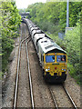
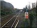
Coal train near Taff's Well
Freightliner's Class 66 locomotive No. 66564 approaches Taffs Well station with an empty working from Aberthaw Power Station to Tower Colliery. In recent weeks, Freightliner has taken over this diagram from DB Cargo.
Image: © Gareth James
Taken: 14 May 2016
0.08 miles