IMAGES TAKEN NEAR TO
Plas Y Mynach, CARDIFF, CF15 8GB
Introduction
This page details the photographs taken nearby to Plas Y Mynach, CF15 8GB by members of the Geograph project.
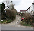
The Geograph project started in 2005 with the aim of publishing, organising and preserving representative images for every square kilometre of Great Britain, Ireland and the Isle of Man.

There are currently over 7.5m images from over14,400 individuals and you can help contribute to the project by visiting https://www.geograph.org.uk
Image Map
Images are licensed for reuse under creativecommons.org/licenses/by-sa/2.0
Notes
- Clicking on the map will re-center to the selected point.
- The higher the marker number, the further away the image location is from the centre of the postcode.
Image Listing (107 Images Found)
Images are licensed for reuse under creativecommons.org/licenses/by-sa/2.0
Image
Details
Distance
1
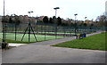
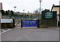
Tennis courts with lights, Radyr Lawn Tennis Club, Cardiff
The club site is set back from the west side of Heol Isaf, accessed via Rectory Close.
Image: © Jaggery
Taken: 5 Mar 2015
0.06 miles
2
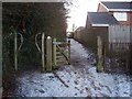
Bridleway leading towards Llantrisant Road
Image: © John Light
Taken: 5 Jan 2010
0.06 miles
3
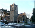
Christ Church, Radyr, Cardiff
Church in Wales church located on the west side of Heol Isaf (B4262).
It was built at the beginning of the 20th century.
Image: © Jaggery
Taken: 29 Nov 2010
0.06 miles
4
Radyr Farm Road, Radyr, Cardiff
Ascending from the west side of the B4262 Heol Isaf. Behind the camera, a bridleway signpost points this way.
Image: © Jaggery
Taken: 26 Jan 2018
0.07 miles
5
Radyr Farm Road, Radyr, Cardiff
Heading west away from the B4262 Heol Isaf opposite the Woodfield Avenue junction.
Image: © Jaggery
Taken: 5 Mar 2015
0.08 miles
6
Entrance to Radyr Lawn Tennis Club, Cardiff
From Rectory Close on the west side of Heol Isaf.
The club was founded in 1914. In its centenary year,
it was 2014 Tennis Wales Club of the Year.
New members always welcome.
Image: © Jaggery
Taken: 5 Mar 2015
0.09 miles
7
Rectory Close, Radyr, Cardiff
Rectory Close leads from the B4262 Heol Isaf to Radyr Medical Centre http://www.geograph.org.uk/photo/4372450 on the right and Radyr Lawn Tennis Club http://www.geograph.org.uk/photo/4372449 on the left. The southern edge of Christ Church http://www.geograph.org.uk/photo/2179871 is on the right.
Image: © Jaggery
Taken: 5 Mar 2015
0.09 miles
8
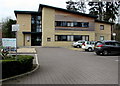
Radyr Medical Centre, Cardiff
At the western end of Rectory Close, accessed from the B4262 Heol Isaf.
Image: © Jaggery
Taken: 5 Mar 2015
0.09 miles
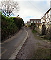
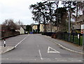
9
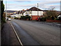
Down Heol Isaf, Radyr, Cardiff
North along the B4262 Heol Isaf towards the centre of the Radyr area of Cardiff.
The Woodfield Avenue junction is on the right.
Image: © Jaggery
Taken: 26 Jan 2018
0.09 miles
10
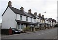
Row of houses, Heol Isaf, Radyr, Cardiff
Looking south away from the centre of Radyr.
Image: © Jaggery
Taken: 5 Mar 2015
0.09 miles