IMAGES TAKEN NEAR TO
Ironbridge Road, CARDIFF, CF15 7NH
Introduction
This page details the photographs taken nearby to Ironbridge Road, CF15 7NH by members of the Geograph project.
The Geograph project started in 2005 with the aim of publishing, organising and preserving representative images for every square kilometre of Great Britain, Ireland and the Isle of Man.

There are currently over 7.5m images from over14,400 individuals and you can help contribute to the project by visiting https://www.geograph.org.uk
Image Map
Images are licensed for reuse under creativecommons.org/licenses/by-sa/2.0
Notes
- Clicking on the map will re-center to the selected point.
- The higher the marker number, the further away the image location is from the centre of the postcode.
Image Listing (75 Images Found)
Images are licensed for reuse under creativecommons.org/licenses/by-sa/2.0
Image
Details
Distance
1
Northern end of Iron Bridge Road, Tongwynlais
Houses on the east side of the road, viewed from Merthyr Road. The west side of the road is here occupied by a primary school. http://www.geograph.org.uk/photo/2181741
Image: © Jaggery
Taken: 29 Nov 2010
0.03 miles
2
Tongwynlais Community Primary School
Viewed across Merthyr Road. The school, dating from 1908, occupies a site on the corner of Merthyr Road and Iron Bridge Road. The school motto is Llwyddiant I Bawb - Success For All.
Image: © Jaggery
Taken: 29 Nov 2010
0.03 miles
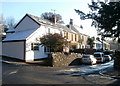
3
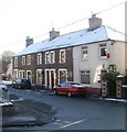
Central part of residential Iron Bridge Road, Tongwynlais
The houses are near a fork in the road http://www.geograph.org.uk/photo/2183048 where Iron Bridge Road splits into a residential arm and an arm leading to the River Taff.
Image: © Jaggery
Taken: 29 Nov 2010
0.04 miles
5
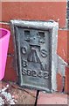
Ordnance Survey Flush Bracket (S9242)
This OS Flush Bracket can be found on the north face of the school. It marks a point 36.868m above mean sea level.
Image: © Adrian Dust
Taken: 20 Jul 2020
0.05 miles
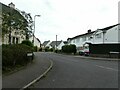
6
Pantgwynlais, Tongwynlais
Houses on the north side of the road, viewed from the corner of Cae Lewis. There are no houses on the southern side of this (western) part of Pantgwynlais. A row of trees shields the houses from traffic on Merthyr Road. There are houses on the south side at the eastern end of Pantgwynlais.
Image: © Jaggery
Taken: 29 Nov 2010
0.05 miles
7
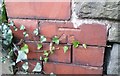
Ordnance Survey Cut Mark
This OS cut mark can be found on the school wall. It marks a point 38.505m above mean sea level.
Image: © Adrian Dust
Taken: 20 Jul 2020
0.05 miles
8
Bethesda United Reformed Church, Tongwynlais
Located between 11 and 13 Merthyr Road, almost opposite the village hall. http://www.geograph.org.uk/photo/2181681
Image: © Jaggery
Taken: 29 Nov 2010
0.08 miles
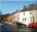
9
Queen Street houses, Tongwynlais
Houses on the north side of Queen Street, between Hermon CM chapel http://www.geograph.org.uk/photo/2181392 and the corner of Cross Street.
Image: © Jaggery
Taken: 29 Nov 2010
0.08 miles
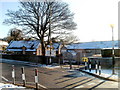
10
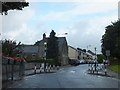
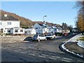
Traffic calming near the school
The school is behind the wall on the left; traffic is slowed to cross the pedestrian crossing with a priority system.
Image: © David Smith
Taken: 7 Jul 2011
0.08 miles