IMAGES TAKEN NEAR TO
Talygarn Street, CARDIFF, CF14 3PT
Introduction
This page details the photographs taken nearby to Talygarn Street, CF14 3PT by members of the Geograph project.
The Geograph project started in 2005 with the aim of publishing, organising and preserving representative images for every square kilometre of Great Britain, Ireland and the Isle of Man.

There are currently over 7.5m images from over14,400 individuals and you can help contribute to the project by visiting https://www.geograph.org.uk
Image Map
Images are licensed for reuse under creativecommons.org/licenses/by-sa/2.0
Notes
- Clicking on the map will re-center to the selected point.
- The higher the marker number, the further away the image location is from the centre of the postcode.
Image Listing (60 Images Found)
Images are licensed for reuse under creativecommons.org/licenses/by-sa/2.0
Image
Details
Distance
1
Allensbank Primary School, Cardiff
Located on Llanishen Street. Built in 1905, the school currently has about 200 pupils enrolled.
School motto "Only our best will do"
Image: © Jaggery
Taken: 14 Apr 2010
0.04 miles
2
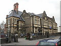
Whitchurch Road, Heath
The A469 passing the junction with Crown Way (left). The parish boundary between Cathays (left) and Gabalfa turns left down Crown Way after following the main road past the camera. The Heath Evangelical Church about 230 metres down the road was completed in 1906.
Image: © Derek Harper
Taken: 16 Jun 2018
0.05 miles
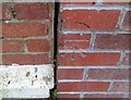
3
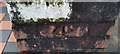
Ordnance Survey Cut Mark
This OS cut mark can be found on the dividing wall between Nos.47 & 49 Manor Street. It marks a point 29.163m above mean sea level.
Image: © Adrian Dust
Taken: 16 Mar 2018
0.06 miles
4
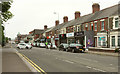
Southern end of Allensbank Road, Cardiff
Allensbank Road heads north away from the A469 (Whitchurch Road).
On the left is the Heath pubhttp://www.geograph.org.uk/photo/1927611 ; on the right is Cathays Cemetery.
Image: © Jaggery
Taken: 3 Sep 2009
0.06 miles
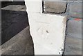
5
Ordnance Survey Cut Mark
This OS cut mark can be found on No39 Allensbank Road. It marks a point 28.606m above mean sea level.
Image: © Adrian Dust
Taken: 11 Nov 2017
0.07 miles
6
Ordnance Survey Cut Mark
This OS cut mark can be found on No84 Whitchurch Road. It marks a point 29.264m above mean sea level.
Image: © Adrian Dust
Taken: 16 Mar 2018
0.07 miles
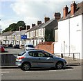
7
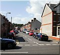
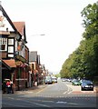
Eastern end of Talygarn Street, Cardiff
Viewed from Allensbank Road. Talygarn Street heads for Whitchurch Road.http://www.geograph.org.uk/photo/1927490
Image: © Jaggery
Taken: 3 Sep 2009
0.07 miles
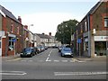
8
Talygarn Street, Cardiff
Talygarn Street bends away from Whitchurch Road, heading for Allensbank Road.http://www.geograph.org.uk/photo/1927676
Image: © Jaggery
Taken: 3 Sep 2009
0.07 miles
9
Eastern end of Allensbank Crescent, Cardiff
Viewed from Allensbank Road.
Railings block off vehicular access. The far end of the crescent http://www.geograph.org.uk/photo/1927580 connects with Whitchurch Road.
Image: © Jaggery
Taken: 3 Sep 2009
0.08 miles
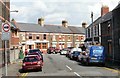
10
Allensbank Crescent, Cardiff
Viewed from Whitchurch Road. Formerly, Allensbank Crescent gave motorists a short cut to Allensbank Road, but now the far end of the crescent is blocked off, http://www.geograph.org.uk/photo/1927658 hence the 'no through road' signs.
Image: © Jaggery
Taken: 3 Sep 2009
0.08 miles