IMAGES TAKEN NEAR TO
Vellacott Close, CARDIFF, CF10 4AT
Introduction
This page details the photographs taken nearby to Vellacott Close, CF10 4AT by members of the Geograph project.
The Geograph project started in 2005 with the aim of publishing, organising and preserving representative images for every square kilometre of Great Britain, Ireland and the Isle of Man.

There are currently over 7.5m images from over14,400 individuals and you can help contribute to the project by visiting https://www.geograph.org.uk
Image Map
Images are licensed for reuse under creativecommons.org/licenses/by-sa/2.0
Notes
- Clicking on the map will re-center to the selected point.
- The higher the marker number, the further away the image location is from the centre of the postcode.
Image Listing (138 Images Found)
Images are licensed for reuse under creativecommons.org/licenses/by-sa/2.0
Image
Details
Distance
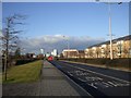
1
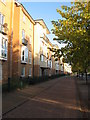
Cycleway beside David Lloyd George Avenue, Cardiff
Image: © Gareth James
Taken: 30 Aug 2010
0.03 miles
2
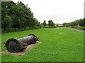
Site of former Bute West Dock
Bute West Dock was filled-in in the late 1960s. Part of its location is now a park, and various bits of maritime heritage remain, including this section of iron pipe.
Image: © Gareth James
Taken: 31 Aug 2009
0.05 miles
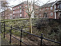
3
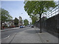
Bute St, Cardiff, northern end
On the left can be seen the twin towers of the Church of St Mary the Virgin & St Stephen the Martyr. The wall on the right supports the embankment for the railway down to Cardiff Bay.
Image: © John Lord
Taken: 28 Apr 2010
0.05 miles
5
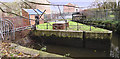
Black Weir Docks Feeder
The sluices control supply of water to the disused, but still in water, Bute East Dock and the remaining docks to the south.
Image: © Guy Butler-Madden
Taken: 16 Dec 2011
0.07 miles
6

Parish church
The parish church of St Mary the Virgin and St Stephen the Martyr was built in 1843 to replace a medieval church. The church is unusual that the apparent main front of the building, seen here from Bute Street, is actually the rear with the front entrance facing west so as to preserve traditional liturgical orientation. Listed, grade II, with details at: http://cadwpublic-api.azurewebsites.net/reports/listedbuilding/FullReport?lang=en&id=13981
Image: © Michael Dibb
Taken: 11 Dec 2016
0.08 miles
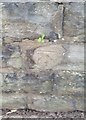
7
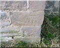
Ordnance Survey Cut Mark
This OS cut mark can be found on the NE face of St Mary's Church. It marks a point 8.101m above mean sea level.
Image: © Adrian Dust
Taken: 3 Feb 2019
0.08 miles
9
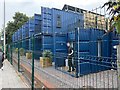
Cargo House Bute Street Containers
Cargo House is an innovative housing project consisting of 13 one and two bedroom apartments built from repurposed shipping containers.
https://www.cadwyn.co.uk/project/cargo-house-bute-street-containers/
Image: © Alan Hughes
Taken: 10 Aug 2020
0.09 miles
10
Ordnance Survey Cut Mark
This OS cut mark can be found on the NE parapet of the canal bridge. It marks a point 11.811m above mean sea level.
Image: © Adrian Dust
Taken: 3 Feb 2019
0.09 miles