IMAGES TAKEN NEAR TO
The Crescent, HAVERHILL, CB9 7DX
Introduction
This page details the photographs taken nearby to The Crescent, CB9 7DX by members of the Geograph project.
The Geograph project started in 2005 with the aim of publishing, organising and preserving representative images for every square kilometre of Great Britain, Ireland and the Isle of Man.

There are currently over 7.5m images from over14,400 individuals and you can help contribute to the project by visiting https://www.geograph.org.uk
Image Map
Images are licensed for reuse under creativecommons.org/licenses/by-sa/2.0
Notes
- Clicking on the map will re-center to the selected point.
- The higher the marker number, the further away the image location is from the centre of the postcode.
Image Listing (88 Images Found)
Images are licensed for reuse under creativecommons.org/licenses/by-sa/2.0
Image
Details
Distance
1
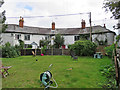
Steeple Bumpstead: The Crescent
This pleasant row's datestone, with a full complement of mid-Victorian full stops, reads
J.S.D.
1849.
Image: © John Sutton
Taken: 20 Aug 2020
0.01 miles
2
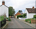
Steeple Bumpstead: down Church Street
The red-brick house in the centre is Gardener's Cottage.
Image: © John Sutton
Taken: 20 Aug 2020
0.01 miles
3
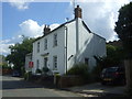
House on Church Street, Steeple Bumpstead
Hands Off Steeple Bumpstead placard refers to an opposition group against a proposed development of 95 houses off Finchingfield Road.
Image: © JThomas
Taken: 2 Sep 2017
0.03 miles
4
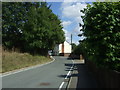
Bend in the B1054, Steeple Bumpstead
Looking north east.
Image: © JThomas
Taken: 2 Sep 2017
0.04 miles
5
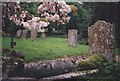
St. Mary's Churchyard, Steeple Bumpstead
Beautiful old grave & headstones from the churchyard at St. Mary's. Some of these dated from the mid-1500s.
Image: © Trudi Barr
Taken: Unknown
0.04 miles
6
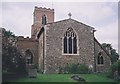
St. Mary's Church, Steeple Bumpstead
This was a lovely old church in a lovely old village and home to some of my grandmother's ancestors for over a 100 years.
Image: © Trudi Barr
Taken: Unknown
0.04 miles
7
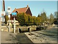
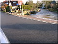
The footbridge on the corner of Church Street
The footbridge is an indication that the stream is known to rise on occasions causing a ford on the road. The road on the right of the picture is Church Street.
Image: © Robert Edwards
Taken: 18 Mar 2009
0.04 miles
10
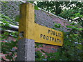
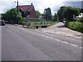
Footpath Sign
Footpath sign at Steeple Bumpstead, Essex.
Image: © Keith Evans
Taken: 4 Oct 2012
0.05 miles