IMAGES TAKEN NEAR TO
Cross Green, NEWMARKET, CB8 9XH
Introduction
This page details the photographs taken nearby to Cross Green, CB8 9XH by members of the Geograph project.
The Geograph project started in 2005 with the aim of publishing, organising and preserving representative images for every square kilometre of Great Britain, Ireland and the Isle of Man.

There are currently over 7.5m images from over14,400 individuals and you can help contribute to the project by visiting https://www.geograph.org.uk
Image Map
Images are licensed for reuse under creativecommons.org/licenses/by-sa/2.0
Notes
- Clicking on the map will re-center to the selected point.
- The higher the marker number, the further away the image location is from the centre of the postcode.
Image Listing (10 Images Found)
Images are licensed for reuse under creativecommons.org/licenses/by-sa/2.0
Image
Details
Distance
1
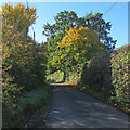
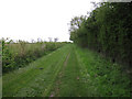
Light, shade and changing colours
A cloudless October morning in the horse-racing country south of Newmarket. This is the single-track dead-end lane to Dullingham Ley and Widgham Green, serving a scattering of houses and a number of stud farms.
Image: © John Sutton
Taken: 18 Oct 2022
0.04 miles
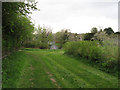
2
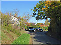
Houses at Cross Green
A straggle of houses on the road from Dullingham Ley to Dullingham.
Image: © John Sutton
Taken: 18 Oct 2022
0.05 miles
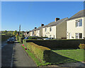
4
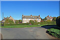
Dullingham: houses on the corner
Council-built houses on the sharp corner where the dead-end lane from Dullingham Ley meets Stetchworth Road on the edge of Dullingham.
Image: © John Sutton
Taken: 18 Oct 2022
0.15 miles
5
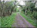
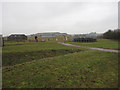
New footpath from Dullingham
Linking with the footpath to Hope Hall.
Image: © Hugh Venables
Taken: 30 Apr 2010
0.20 miles
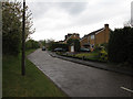
6
Down Stetchworth Road
Council-built houses between Stetchworth and Dullingham (ahead).
Image: © John Sutton
Taken: 18 Oct 2022
0.21 miles
7
Algar Drive
Relatively new housing between Dullingham and Stetchworth.
Image: © Hugh Venables
Taken: 30 Apr 2010
0.21 miles
8
New footpath
Not marked on the map but usefully linking to the footpath to Hope Hall.
Image: © Hugh Venables
Taken: 30 Apr 2010
0.23 miles
9
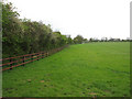
Horse field
No horses present but the wooden fence is typical of horse fields, and most land in this area is used for horses.
Image: © Hugh Venables
Taken: 30 Apr 2010
0.24 miles
10
Hope Hall Stable Yard
One of several new large houses in the area - horse money.
Image: © Hugh Venables
Taken: 24 Jan 2010
0.24 miles