IMAGES TAKEN NEAR TO
Cowlinge Road, NEWMARKET, CB8 9HL
Introduction
This page details the photographs taken nearby to Cowlinge Road, CB8 9HL by members of the Geograph project.
The Geograph project started in 2005 with the aim of publishing, organising and preserving representative images for every square kilometre of Great Britain, Ireland and the Isle of Man.

There are currently over 7.5m images from over14,400 individuals and you can help contribute to the project by visiting https://www.geograph.org.uk
Image Map
Images are licensed for reuse under creativecommons.org/licenses/by-sa/2.0
Notes
- Clicking on the map will re-center to the selected point.
- The higher the marker number, the further away the image location is from the centre of the postcode.
Image Listing (7 Images Found)
Images are licensed for reuse under creativecommons.org/licenses/by-sa/2.0
Image
Details
Distance
1
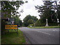
Kirtling Cross Roads
Looking W towards Saxon Street. To the left of the war memorial is the village sign. For detail see http://www.kirtlingandupend.org.uk
Image: © mike
Taken: 24 Sep 2005
0.06 miles
2
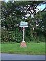
Kirtling and Upend village sign
The sign is located on Cowlinge Road in Kirtling next to the War Memorial
Image: © Adrian S Pye
Taken: 25 Oct 2009
0.06 miles
3

Kirtling & Upend village sign and War Memorial
Image: © Robert Edwards
Taken: 8 Aug 2007
0.08 miles
5
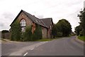
The old school at Kirtling
The road is called The Street. The school is now converted into a private house.
Image: © Robert Edwards
Taken: 3 Aug 2009
0.21 miles
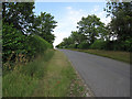
6
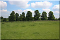
Avenue of trees
Extending from Kirtling Towers.
Image: © Hugh Venables
Taken: 31 May 2008
0.21 miles
7
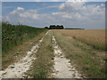
Footpath to Prince of Wales Wood
Following a farm track.
Image: © Hugh Venables
Taken: 24 Jul 2010
0.22 miles