IMAGES TAKEN NEAR TO
Thorns Corner, NEWMARKET, CB8 8XW
Introduction
This page details the photographs taken nearby to Thorns Corner, CB8 8XW by members of the Geograph project.
The Geograph project started in 2005 with the aim of publishing, organising and preserving representative images for every square kilometre of Great Britain, Ireland and the Isle of Man.

There are currently over 7.5m images from over14,400 individuals and you can help contribute to the project by visiting https://www.geograph.org.uk
Image Map
Images are licensed for reuse under creativecommons.org/licenses/by-sa/2.0
Notes
- Clicking on the map will re-center to the selected point.
- The higher the marker number, the further away the image location is from the centre of the postcode.
Image Listing (13 Images Found)
Images are licensed for reuse under creativecommons.org/licenses/by-sa/2.0
Image
Details
Distance
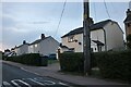
1
House at the crossroads
A sunny house on a sunny day.
Image: © Robin Webster
Taken: 8 Apr 2017
0.03 miles
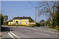
2
Premier Store and Post Office, Wickhambrook
At the junction known as Thorns Corner. The post box is CB8 49.
Image: © Keith Edkins
Taken: 13 Nov 2018
0.03 miles
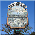
3

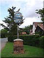
Wickhambrook village sign (north face)
On this side the crown at the top represents the visit of Princess Anne to the village in 1979. The upper panel shows two of the village crafts, bakery and thatching, and the two pubs, The Greyhound and The Cloak, in the background, the latter having closed in 1989 The tree between them represents the orchards of Justin Brooke of Clopton Hall.
The lower panel depicts the Victorian school with the children playing. The post box, dating from 1859 and the only one of its kind in the British Isles. The south face can be seen here https://www.geograph.org.uk/photo/6790517
https://www.geograph.org.uk/photo/4295586
Thanks to Peter Miller and Wickhambrook website
Image: © Adrian S Pye
Taken: 29 Mar 2021
0.03 miles
4
Wickhambrook village sign (south face)
At the top of the sign just below the name is a comedy and tragedy mask probably representing pantomime and the parish carnival held annually. The scene above the centre depicts All Saints church, the old post-mill known as Bullock's Mill which was built at Thorns corner about 1830, and demolished about 1914. The thatched cottage is one of many in the village. The bridge over the River Glem has been modernised and kingfishers and herons are infrequent visitors. The farmer in the field stooking-up sheaves represents the arable farms in the parish. The bar between the panels depicts the leaves and fruit of the trees common to the village with, at its centre, a likeness of a carving of a man with spear and shield which can be seen at the church. On the bottom panel, the house in the background represents the manor houses of the village, the playing field and our eleven village greens; Cricket in the village dates back to the 1800s. The spectator with the dog, and wearing a stovepipe hat has handcuffs draped over his arm, the village peeler or beadle no doubt. The north face can be seen here https://www.geograph.org.uk/photo/6790512
https://www.geograph.org.uk/photo/4295586
Thanks to Peter Miller and Wickhambrook website
Image: © Adrian S Pye
Taken: 29 Mar 2021
0.03 miles
5
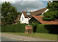
Wickhambrook village sign
At the top of the sign just below the name is a comedy and tragedy mask probably representing pantomime and the parish carnival held annually. The scene above the centre depicts All Saints church, the old post-mill known as Bullock's Mill which was built at Thorns corner about 1830, and demolished about 1914. The thatched cottage is one of many in the village. The bridge over the River Glem has been modernised and kingfishers and herons are infrequent visitors. The farmer in the field stooking-up sheaves represents the arable farms in the parish. The bar between the panels depicts the leaves and fruit of the trees common to the village with, at its centre, a likeness of a carving of a man with spear and shield which can be seen at the church. On the bottom panel, the house in the background represents the manor houses of the village, the playing field and our eleven village greens; Cricket in the village dates back to the 1800s. The spectator with the dog, and wearing a stovepipe hat has handcuffs draped over his arm, the village peeler or beadle no doubt.
On the other side (b) the crown at the top represents the visit of Princess Anne to the village in 1979. The upper panel shows two of the village crafts, bakery and thatching, and the two pubs, The Greyhound and The Cloak, in the background, the latter having closed in 1989 The tree between them represents the orchards of Justin Brooke of Clopton Hall.
The lower panel depicts the Victorian school with the children playing. The post box, dating from 1859 and the only one of its kind in the British Isles.
Close ups of each side https://www.geograph.org.uk/photo/6790512 https://www.geograph.org.uk/photo/6790517
Thanks to Peter Miller and Wickhambrook website.
Image: © Adrian S Pye
Taken: 17 Aug 2007
0.03 miles
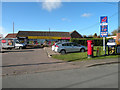
6
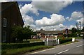
Wickhambrook
The centre of the village, with post office/shop, garage and on the left, a Methodist chapel.
Image: © Bob Jones
Taken: 22 Jun 2006
0.04 miles
7
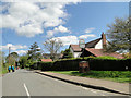
The village sign at Wickhambrook
The sign stands in Cemetery Road.
Image: © Robert Edwards
Taken: 10 Jul 2009
0.05 miles
8
Strolling down Cemetery Road, Wickhambrook
Image: © Adrian S Pye
Taken: 27 Apr 2015
0.06 miles
9
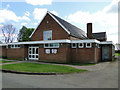
The Memorial Hall, Wickhambrook
Built just after WW2 as a memorial to the six men who never returned.
Image: © Adrian S Pye
Taken: 27 Apr 2015
0.07 miles