
Wickhambrook village sign (south face)
Introduction
The photograph on this page of Wickhambrook village sign (south face) by Adrian S Pye as part of the Geograph project.
The Geograph project started in 2005 with the aim of publishing, organising and preserving representative images for every square kilometre of Great Britain, Ireland and the Isle of Man.

There are currently over 7.5m images from over 14,400 individuals and you can help contribute to the project by visiting https://www.geograph.org.uk
Wickhambrook village sign (south face)
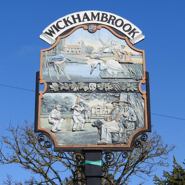
Image: © Adrian S Pye Taken: 29 Mar 2021
At the top of the sign just below the name is a comedy and tragedy mask probably representing pantomime and the parish carnival held annually. The scene above the centre depicts All Saints church, the old post-mill known as Bullock's Mill which was built at Thorns corner about 1830, and demolished about 1914. The thatched cottage is one of many in the village. The bridge over the River Glem has been modernised and kingfishers and herons are infrequent visitors. The farmer in the field stooking-up sheaves represents the arable farms in the parish. The bar between the panels depicts the leaves and fruit of the trees common to the village with, at its centre, a likeness of a carving of a man with spear and shield which can be seen at the church. On the bottom panel, the house in the background represents the manor houses of the village, the playing field and our eleven village greens; Cricket in the village dates back to the 1800s. The spectator with the dog, and wearing a stovepipe hat has handcuffs draped over his arm, the village peeler or beadle no doubt. The north face can be seen here https://www.geograph.org.uk/photo/6790512 https://www.geograph.org.uk/photo/4295586 Thanks to Peter Miller and Wickhambrook website
Images are licensed for reuse under creativecommons.org/licenses/by-sa/2.0
Image Location

Latitude
52.168319
Longitude
0.549365