IMAGES TAKEN NEAR TO
Landwade Road, NEWMARKET, CB8 7NL
Introduction
This page details the photographs taken nearby to Landwade Road, CB8 7NL by members of the Geograph project.
The Geograph project started in 2005 with the aim of publishing, organising and preserving representative images for every square kilometre of Great Britain, Ireland and the Isle of Man.

There are currently over 7.5m images from over14,400 individuals and you can help contribute to the project by visiting https://www.geograph.org.uk
Image Map
Images are licensed for reuse under creativecommons.org/licenses/by-sa/2.0
Notes
- Clicking on the map will re-center to the selected point.
- The higher the marker number, the further away the image location is from the centre of the postcode.
Image Listing (8 Images Found)
Images are licensed for reuse under creativecommons.org/licenses/by-sa/2.0
Image
Details
Distance
2
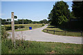
Footpath to Landwade Farm
The signpost indicates the junction of a footpath, which leads to Landwade Farm, and a restricted byway. The footpath initially follows a metalled farm track. The restricted byway links the hamlet of Landwade with North End road.
Image: © Bob Jones
Taken: 28 Jun 2010
0.03 miles
3
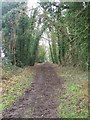
Track to West Fen
This track is a continuation of Landwade Road, which ends just short of this point. It leads to a low-lying area of farmland and is not a public right of way.
Image: © Bob Jones
Taken: 28 Jun 2010
0.08 miles
4
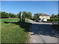
Open-sided barn at Landwade
This barn is situated near the entrance to Landwade Farm, part of Exning Estates. A public footpath, leading past the farm, follows the metalled track.
Image: © Bob Jones
Taken: 28 Jun 2010
0.08 miles
5
Footpath
Footpath near to Landwade, Suffolk.
Image: © Keith Evans
Taken: 7 Feb 2017
0.09 miles
6
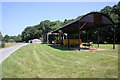
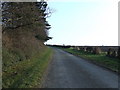
Landwade Road heading to Landwade
North of Newmarket in Suffolk
Image: © Richard Humphrey
Taken: 30 Apr 2011
0.13 miles
7
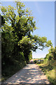
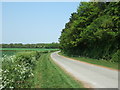
Landwade Road
Looking south west along Landwade Road near to Landwade, Suffolk.
Image: © Keith Evans
Taken: 17 Jan 2010
0.15 miles
8
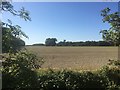
Site of Stephenson's Siding
The line of trees visible across the field are along the line of the former railway siding that linked the former Cambridge to Mildenhall Railway with the nearby Cement Works in the early twentieth century.
Image: © Ajay Tegala
Taken: 21 Sep 2019
0.16 miles