IMAGES TAKEN NEAR TO
High Street, ELY, CB6 3PG
Introduction
This page details the photographs taken nearby to High Street, CB6 3PG by members of the Geograph project.
The Geograph project started in 2005 with the aim of publishing, organising and preserving representative images for every square kilometre of Great Britain, Ireland and the Isle of Man.

There are currently over 7.5m images from over14,400 individuals and you can help contribute to the project by visiting https://www.geograph.org.uk
Image Map
Images are licensed for reuse under creativecommons.org/licenses/by-sa/2.0
Notes
- Clicking on the map will re-center to the selected point.
- The higher the marker number, the further away the image location is from the centre of the postcode.
Image Listing (45 Images Found)
Images are licensed for reuse under creativecommons.org/licenses/by-sa/2.0
Image
Details
Distance
1
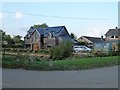
Modern house in Aldreth, Cambridgeshire
Image: © Richard Humphrey
Taken: 15 Oct 2016
0.05 miles
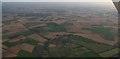
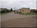
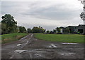
3
Aldreth: High Street
When, long ago, the Isle of Ely was an island in the undrained fens, Aldreth was at its southern edge. This road starts a little above sea level and crosses the 35m/115ft contour at Haddenham.
Image: © John Sutton
Taken: 21 Oct 2016
0.06 miles
4
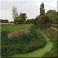
Aldreth: New Cut Drain
A dike which skirts the 30m ridge on which Aldreth stands.
Image: © John Sutton
Taken: 21 Oct 2016
0.06 miles
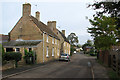
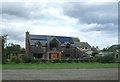
7
New housing in Aldreth
A few extra houses squeezed in at the south end of Aldreth.
Image: © Hugh Venables
Taken: 7 Sep 2009
0.07 miles
9

The New Cut Drain, Aldreth
This drain is taking floodwater towards the camera and then off to the left into the Great Ouse.
Image: © David Purchase
Taken: 21 Oct 2016
0.08 miles
10
Aldreth: Fen Side
The Aldreth end of a network of lanes and byways on Holme Fen - a roundabout route to Haddenham.
Image: © John Sutton
Taken: 21 Oct 2016
0.09 miles