IMAGES TAKEN NEAR TO
Ribston Way, CAMBRIDGE, CB4 1FT
Introduction
This page details the photographs taken nearby to Ribston Way, CB4 1FT by members of the Geograph project.
The Geograph project started in 2005 with the aim of publishing, organising and preserving representative images for every square kilometre of Great Britain, Ireland and the Isle of Man.

There are currently over 7.5m images from over14,400 individuals and you can help contribute to the project by visiting https://www.geograph.org.uk
Image Map
Images are licensed for reuse under creativecommons.org/licenses/by-sa/2.0
Notes
- Clicking on the map will re-center to the selected point.
- The higher the marker number, the further away the image location is from the centre of the postcode.
Image Listing (232 Images Found)
Images are licensed for reuse under creativecommons.org/licenses/by-sa/2.0
Image
Details
Distance
1
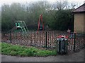
Small play area
On the edge of Bramblefields.
Image: © Hugh Venables
Taken: 21 Mar 2008
0.04 miles
2
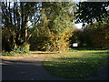
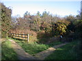
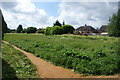
Entrance to Bramblefields local nature reserve
"At the turn of the 20th Century this region was fen and farmland. More recently it was used as allotments but these were abandoned after poor yields. Today Bramblefields provides an idyllic haven for wildlife and people in the midst of a residential area. Local Nature Reserve status has helped safeguard the site from future development and with it a commitment to protecting its wildlife and community value."-From the Welcome notice.
Image: © Keith Edkins
Taken: 6 Nov 2007
0.06 miles
3
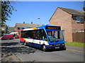
Bus on Fen Estate
A 17 lays over on Fairbairn Road in Fen Estate before making its long and winding journey to Newmarket via Cambridge city centre and Fulbourn. Due to bus service funding cuts at Cambridgeshire County Council, this route no longer continues to Newmarket.
Image: © Richard Vince
Taken: 26 May 2012
0.07 miles
4
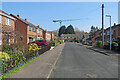
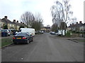
Chesterton: Bourne Road
A council-built estate in one of the northern suburbs of Cambridge. The crane is on the construction site opposite Cambridge North railway station.
Image: © John Sutton
Taken: 23 Mar 2022
0.09 miles
5
Pond on Bramblefields local nature reserve
"The fluctuations in the level of the small pond provide ideal conditions for breeding amphibians and insects such as the Broad Bodied Chaser Dragonfly. The pond is carefully managed to benefit these species by maintaining areas of open water."-from the Welcome notice.
In this photo the pond has indeed just been carefully managed by the local conservation volunteers, which involved removing a lot of iris leaves, two bicycle frames, one wheel and an X-box!
Image: © Keith Edkins
Taken: 6 Nov 2007
0.10 miles
6
Cam Causeway, Cambridge
Looking south east.
Image: © JThomas
Taken: 18 Feb 2017
0.10 miles
8
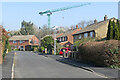
Chesterton: Long Reach Road and a crane
A council-built estate in one of the northern suburbs of Cambridge. The crane is on the construction site opposite Cambridge North railway station.
Image: © John Sutton
Taken: 23 Mar 2022
0.13 miles
9
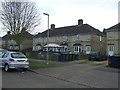
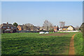
Open space in Chesterton
A strip of land that was left between the houses when the estate was built. See Image for an explanation.
Image: © Bill Boaden
Taken: 25 May 2014
0.13 miles
10
Chesterton: a green space
Between the back gardens of Lents Way (left) and Cheney Way (offstage right)
Image: © John Sutton
Taken: 23 Mar 2022
0.13 miles