IMAGES TAKEN NEAR TO
Castle Park, CAMBRIDGE, CB3 0AX
Introduction
This page details the photographs taken nearby to Castle Park, CB3 0AX by members of the Geograph project.
The Geograph project started in 2005 with the aim of publishing, organising and preserving representative images for every square kilometre of Great Britain, Ireland and the Isle of Man.

There are currently over 7.5m images from over14,400 individuals and you can help contribute to the project by visiting https://www.geograph.org.uk
Image Map
Images are licensed for reuse under creativecommons.org/licenses/by-sa/2.0
Notes
- Clicking on the map will re-center to the selected point.
- The higher the marker number, the further away the image location is from the centre of the postcode.
Image Listing (917 Images Found)
Images are licensed for reuse under creativecommons.org/licenses/by-sa/2.0
Image
Details
Distance
1
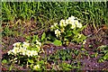
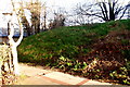
Primroses (Primula vulgaris)
Part of the Shire Hall site is managed as a nature reserve. These spring flowers are growing on the earthwork that formed part of the Civil War defences of Cambridge Castle. For a wider view of the location and history of the fortifications see Image
Image: © Tiger
Taken: 9 Apr 2008
0.02 miles
3
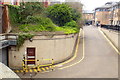
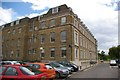
Secret nuclear bunker
A secret no longer, as it has been featured in the local press and even opened its unassuming door (behind the yellow railings) to visitors during Heritage Open Days.
Concealed beneath the former Castle Court offices on the Shire Hall site and covered by a living roof, the bunker would have provided a safe refuge for council officers to coordinate responses to any nuclear incident affecting the area.
Protected by an airlock and two blast doors, it provides working space and living accommodation for up to 40 personnel. There is a communications suite to enable enquiries from the public to be answered and information and advice to be broadcast to the local population. It has its own independent power supply and reserves of fuel and water to permit it to operate off grid.
Over the years the facility has been used not only for civil defence training exercises but as a call centre in response to local flooding and other emergency incidents. It now provides archive storage for the County Council's archaeology unit.
https://www.cambridge-news.co.uk/news/cambridge-news/gallery/shire-halls-secret-nuclear-bunker-13824512
Image: © Tiger
Taken: 8 Apr 2019
0.02 miles
4
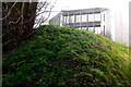
Cromwellian earthworks
At the beginning of the English Civil War in 1642, Cambridge Castle was occupied by Parliamentary forces. The townsfolk mainly supported Oliver Cromwell, their local hero with his background in Huntingdon and Ely, but the University and Colleges were a hotbed of Royalism. Cromwell ordered the long-neglected fortifications to be beefed up as a defence against this threat, and so two earthen bastions of earth were hastily constructed. In the event no assaults took place and in 1647 the remains of the castle were slighted.
The grassy mound seen here is the remains of the northern bastion, which stands on the eastern edge of the Shire Hall office site. The roof beyond belongs to Wessex Place in Magrath Avenue, built on the site of the former Rex Cinema as sheltered housing for the vulnerable, subsequently converted into a graduate hostel for Trinity College. For a view from the opposite direction see Image
Image: © Tiger
Taken: 1 Feb 2020
0.02 miles
5
Northern bastion of Cambridge Castle
At the beginning of the English Civil War in 1642, Cambridge Castle was occupied by Parliamentary forces. The townsfolk mainly supported Oliver Cromwell, their local hero with his background in Huntingdon and Ely, but the University and Colleges were a hotbed of Royalism. Cromwell ordered the long-neglected fortifications to be beefed up as a defence against this threat, and so two earthen bastions of earth were hastily constructed. In the event no assaults took place and in 1647 the remains of the castle were slighted.
The grassy mound seen here is the remains of the northern bastion, which stands on the eastern edge of the Shire Hall office site. Looming above it is the Octagon, part of the 1974 concrete extensions to the county offices, designed by John Pook of the County Architect's Department and dismissed by Simon Bradley in his 2014 revision of Pevsner's guide as "depressing". For a view from the opposite direction see Image
Image: © Tiger
Taken: 1 Feb 2020
0.02 miles
8

The last Christmas tree at Wessex Place
Wessex Place residential home in Magrath Avenue had 19 residents aged over 65 with mental health problems. NHS Cambridgeshire and Granta Housing Society decided to close the unit. Supporters say that no plans for alternative care have been put forward. They fear that frail residents could die if they are moved.
Image: © Tiger
Taken: 21 Dec 2008
0.03 miles
9
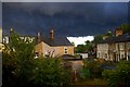
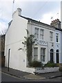
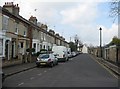
Looking black over Bill's mother's!
An evening thunderstorm settles in over Clare Street.
Image: © Tiger
Taken: 3 Jul 2007
0.03 miles